Florida’s Weather Whiplash: Patchy Morning Fog Across Tampa Bay Before Big Warmup, Then Strong Cold Front and Wind Chills in the 20s Early Next Week
FLORIDA — A stretch of dramatic weather swings is unfolding across the Tampa Bay region, beginning with patchy morning fog, followed by a noticeable warmup, and ending with a strong cold front that could drive wind chills into the 20s by Tuesday morning. The rapid changes have forecasters describing the setup as classic Florida weather whiplash.
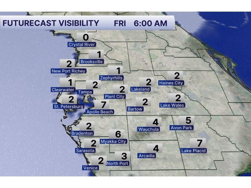
Patchy Fog Reduces Visibility Friday Morning
Early morning visibility forecasts for Friday at 6:00 AM show areas of reduced visibility across parts of west-central Florida.
Some of the lowest visibility readings include:
- Crystal River: near 0 miles
- Brooksville: around 1 mile
- New Port Richey: around 2 miles
- Clearwater: near 1 mile
- Tampa and St. Petersburg: near 2 miles
- Lakeland, Haines City, Lake Wales: around 2 miles
- Sarasota and Venice: near 2 miles
Drivers in fog-prone areas were urged to slow down and use low-beam headlights during the early commute, especially near coastal and inland low-lying regions.
While the fog is expected to lift later in the morning, it marks the beginning of a highly variable weather pattern.
Big Warmup Later in the Day
Once the fog clears, temperatures are expected to climb significantly during the afternoon hours.
The warmup will feel springlike across much of the region before the next major change arrives. Calm conditions and milder air ahead of an approaching system will help boost daytime highs.
However, the warm stretch will be short-lived.
Strong Cold Front Arrives Sunday
A powerful cold front is forecast to sweep through Florida on Sunday, bringing a sharp drop in temperatures and increasing winds.
Behind the front, much colder air will pour into the region. The transition from warm and humid conditions to breezy and colder weather will be noticeable within hours.
Residents can expect:
- Gusty winds behind the front
- A rapid temperature drop Sunday night
- Cooler and drier air settling in early next week
Wind Chills in the 20s by Tuesday Morning
By Tuesday morning, wind chill values could dip into the 20s in parts of the region — a stark contrast to the warm conditions expected just days prior.
Even if actual air temperatures remain slightly higher, the combination of colder air and wind will make it feel significantly colder during early morning hours.
For Florida, wind chills in the 20s represent a substantial cold snap and could impact:
- Early morning commuters
- Outdoor workers
- Sensitive plants
- Pets left outdoors
A Week of Rapid Swings
From foggy mornings to springlike afternoons and then winterlike wind chills, the upcoming stretch highlights just how quickly conditions can change during transitional seasons.
Residents across Florida are encouraged to:
- Use caution during foggy morning commutes
- Monitor updated forecasts heading into the weekend
- Prepare for colder conditions early next week
Weather officials stress that staying informed is key as each phase of this pattern unfolds. Stay with SaludaStandard-Sentinel.com for continued updates on this rapidly changing weather pattern across Florida.