Ohio and Indiana Face Evening Severe Storm Risk as Warm Front Targets Areas South of US-36 With Damaging Wind Threat
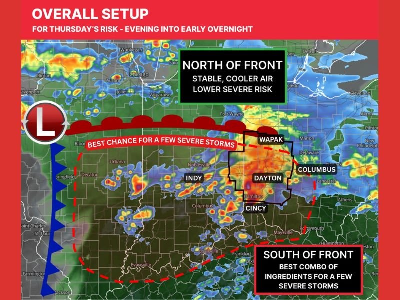
OHIO — An evolving warm front and increasing wind shear are setting the stage for a few potential severe storms Thursday evening into early Friday, especially for communities near and south of US-36 in Ohio and Indiana.
Forecasters say this is not a guaranteed outbreak, but enough ingredients are in place to warrant close monitoring between 5 p.m. and 1 a.m.
Warm Front Lifting North Enhances Storm Potential
For February, this is considered an active setup. A warm front lifting north is allowing mid-50s dewpoints to move into parts of Ohio and Indiana.
While those moisture levels are not extreme, warm fronts often act as an enhancer by increasing the potential for rotating thunderstorms. However, rotation alone does not guarantee tornado formation.
North of the front, cooler and more stable air will likely limit the severe risk. South of the boundary, the overlap of lift and wind shear creates a more favorable zone for a few stronger storms .
Best Chance South of US-36 in Ohio and Indiana
Communities near and south of US-36 appear to have the best overall chance of seeing a few severe storms. This includes areas around Dayton, Cincinnati, Columbus and nearby Indiana communities west of the state line.
Storms are expected to move northeast through the evening, and the most favorable corridor for stronger development aligns just south of the warm front. Limited moisture and instability remain potential limiting factors, meaning the setup could underperform in some locations.
Damaging Winds Primary Threat, Tornado Risk Low but Not Zero
The main concern with this system is damaging wind gusts. Some storms may initially develop as individual supercells before merging into clusters or a broken line. When that happens, the risk often shifts more toward wind damage. With a warm front nearby, a brief or isolated tornado cannot be ruled out, though the overall tornado risk remains low.
Timing: 5 PM to 1 AM Window
The most favorable window for stronger storms appears to be between 5 p.m. and 1 a.m., though that timing could shift slightly earlier or later. A secondary line of storms may develop near the advancing cold front overnight, but the severe threat with that feature appears lower.
Residents across southern Ohio and parts of eastern Indiana should stay weather-aware during the evening hours and ensure they have multiple ways to receive warnings.
If you live in Ohio or Indiana and are preparing for Thursday night’s storms, share your updates and preparedness plans with us at SaludaStandard-Sentinel.com. Community awareness helps keep everyone informed during evolving weather situations.