Central Alabama Enters Warmest Stretch Since Early January as Mid-February Brings Rain-Heavy Pattern Instead of Arctic Cold
CENTRAL ALABAMA — Central Alabama is heading into its warmest stretch of weather since early January, marking a notable shift away from the repeated Arctic intrusions that dominated much of winter. Forecast data shows temperatures climbing well above seasonal averages this week, with no significant Arctic air expected for at least the next seven to ten days. While this does not rule out future cold snaps later in February, the immediate pattern favors warmth, clouds, and increasing rainfall rather than another deep freeze.
A Sustained Warmup Takes Hold Across the Region
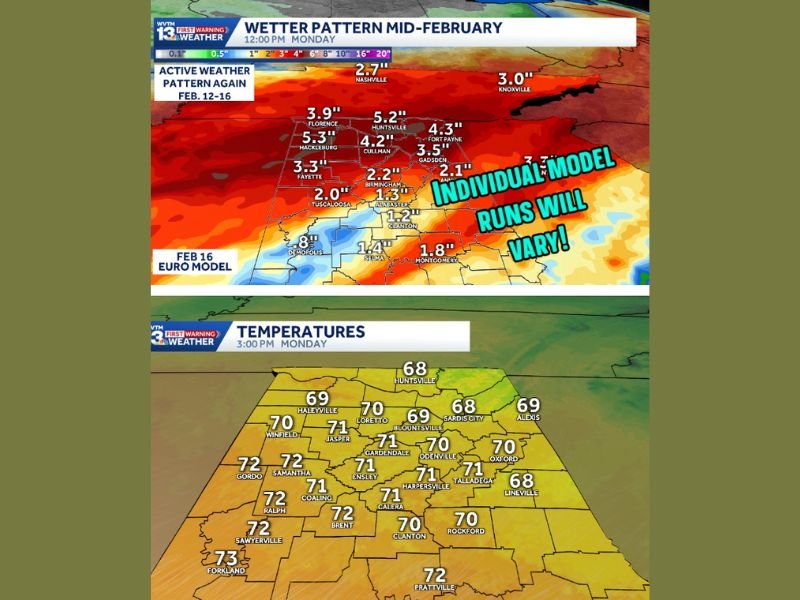
Between January 4 and January 10, Birmingham’s average daily high hovered near 65 degrees. This week’s temperatures are expected to reach or exceed those levels, with highs staying in the upper 60s to lower 70s through much of the forecast period. Monday begins the trend with mostly sunny skies and highs in the lower 70s, supported by light southwest winds. Tuesday remains warm but turns more humid, with highs in the upper 60s as cloud cover increases.
This pattern represents a clear departure from the colder, Arctic-driven systems that recently affected the region. While temperatures may still fluctuate and occasional cool mornings remain possible, there is no indication of a return to prolonged Arctic cold in the short term.
Clouds and Rain Replace Cold as the Primary Concern
The tradeoff with this warmer pattern will be increasing cloud cover and multiple rounds of rain. From Tuesday through Friday, Central Alabama can expect occasional showers, though most rainfall during this period should be light and scattered. Rain chances increase later in the week as a more organized system approaches.
Wednesday and Thursday are expected to remain mostly cloudy, with highs in the mid to upper 60s. Rain chances during this time will be higher north of Central Alabama, particularly across the Tennessee Valley, but some showers may still drift south.
Widespread Soaking Rain Expected Late Week Into the Weekend
The most impactful weather of the week is expected from Friday night through Sunday morning. Forecast guidance supports a period of widespread, soaking rain as a more active weather system moves through the region. Rainfall totals during this window could reach one to two inches in some locations, especially during periods of heavier rain and possible thunderstorms on Saturday.
Friday will begin cloudy, with rain developing during the day and becoming widespread by evening. Highs will remain in the lower to middle 60s. Saturday, which coincides with Valentine’s Day, is expected to be unsettled, with rain and thunderstorms likely and temperatures ranging from the upper 50s to lower 60s. Sunday should see rain gradually ending by early afternoon, followed by lingering clouds and highs in the upper 50s to lower 60s.
What This Pattern Means Moving Forward
While winter is far from over, the current forecast strongly favors a warmer, wetter mid-February across Central Alabama. This stretch will help break the grip of recent cold spells but could lead to soggy conditions and localized drainage issues where heavier rain falls. Residents should remain aware of changing conditions, especially late in the week, as rainfall totals and storm timing become clearer.
For now, Central Alabama’s focus shifts from Arctic cold to umbrellas and rain gauges as the region settles into a milder, rain-dominated weather pattern.