North Carolina Sees Cold Monday Transition Into Midweek Warm-Up With 50s, 60s, and Even 70s Possible
NORTH CAROLINA — A new week is underway across the state, and while Monday begins on a chilly note, a noticeable warming trend is setting the stage for much milder temperatures by Tuesday.
Cold Start Gives Way to Quiet, Sunny Conditions Monday
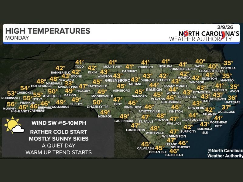
Monday begins very cold across much of North Carolina, continuing the wintry feel left behind from the weekend. Despite the cold start, conditions remain calm and dry throughout the day, with mostly sunny skies and quiet weather dominating the forecast.
High temperatures are expected to reach the 40s statewide, representing a modest improvement compared to Sunday.
Warm Front Begins Moving In Late Monday
As the day progresses, a warm front begins lifting northward, setting the groundwork for a significant temperature rebound. Winds remain light, generally out of the southwest at 5 to 10 mph, helping initiate the warming trend without bringing in unsettled weather.
Tuesday Expected to Bring the Warmest Day of the Week
By Tuesday, warmer air becomes firmly established across the region. Forecast data supports highs in the 50s and 60s, with even some areas reaching the 70s, making it the warmest day of the upcoming week.
Forecasters describe Tuesday as a standout day in the seven-day outlook, with pleasant temperatures and continued dry conditions.
Warm-Up Marks a Clear Shift in the Pattern
The transition from Monday’s cold start to Tuesday’s springlike warmth marks a clear shift in the overall weather pattern across North Carolina. After several colder days, the developing warm front signals a temporary break from winter-like conditions.
Residents can expect improving comfort levels as the week begins, with Tuesday shaping up as the most favorable day ahead.
For continued updates and full regional coverage, stay with SaludaStandard-Sentinel.com.