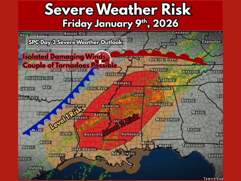
Possible Severe Weather Risk With Isolated Tornadoes For Arkansas, Mississippi, Louisiana, Tennessee and Alabama On Friday
ARKANSAS — A developing storm system is expected to bring a renewed risk of severe weather across portions of the Lower Mississippi Valley and Mid-South on Friday, January 9, 2026, according to updated severe weather outlooks. While the overall threat level remains on the lower end of the severe scale, forecasters warn that isolated damaging storms and a few tornadoes cannot be ruled out, particularly from late morning through the evening hours.
The greatest concern stretches from eastern Texas and Arkansas into northern Louisiana, western Mississippi, and parts of Tennessee and Alabama, where atmospheric conditions may briefly align to support rotating thunderstorms.
Areas Included in the Severe Weather Risk
Forecast guidance places a broad region under a Level 1 (Marginal) to Level 2 (Slight) risk, meaning most storms are expected to remain below severe limits, but a handful could intensify rapidly.
The primary areas of concern include:
- Arkansas, including Little Rock, Jonesboro, and surrounding regions
- Northern Louisiana, especially near Shreveport and Alexandria
- Mississippi, including the Jackson, Greenville, and Hattiesburg areas
- Western and Central Tennessee, including Memphis
- Northern Alabama, including Huntsville and nearby communities
Not all locations within these zones will experience severe weather, but storms that become organized may produce brief, impactful conditions.
What Meteorologists Are Watching Closely
While overall instability levels are expected to be modest, wind shear across the region is notably strong, increasing the potential for storm rotation. This setup allows even marginal storms to pose a localized threat.
Forecasters note that:
- Multiple bands of thunderstorms may develop
- Some storms could take on supercell characteristics
- Stronger updrafts may briefly rotate
This combination raises concern for isolated damaging wind gusts and one or two tornadoes, particularly in the Level 2 risk zone.
Timing of the Greatest Threat
The most favorable window for severe weather development is expected from late morning through the evening hours on Friday. Storms are forecast to initiate earlier in the west before spreading eastward through the afternoon and early evening. Residents should be aware that storms may arrive in waves, and conditions could change quickly as stronger cells move through.
Main Hazards Expected
While widespread severe weather is not anticipated, the primary threats include:
- Isolated damaging straight-line winds
- Brief, fast-moving tornadoes
- Heavy rainfall within stronger storms
Because storms may be scattered, some communities could see little impact while others experience sudden severe conditions.
Why This Setup Still Matters
Even low-end severe weather setups can produce high-impact events when wind shear is strong. Meteorologists stress that January severe weather events often involve fast-moving storms, giving people less time to react if warnings are issued. Nighttime and low-visibility tornadoes are also historically more dangerous, making situational awareness critical.
Preparedness and Safety Guidance
Residents across the risk area are encouraged to:
- Monitor local forecasts and weather alerts
- Ensure warning systems are enabled on mobile devices
- Review tornado safety plans ahead of time
- Avoid complacency due to the “low” risk label
Bottom Line
A broad swath of the Lower Mississippi Valley and Mid-South, including Arkansas, Mississippi, Louisiana, Tennessee, and Alabama, faces a low but meaningful risk of severe weather on Friday. While most storms will remain non-severe, a few may intensify enough to produce damaging winds or brief tornadoes, especially during the afternoon and evening.
Weather conditions will continue to be refined as the event approaches, and residents are urged to stay alert for updates as Friday unfolds.
For continued severe weather updates, local alerts, and developing forecasts across the Southeast, follow coverage from SaludaStandard-Sentinel.com and share your local conditions with our newsroom.