Acadiana Braces for Friday Night Cold Front as Severe Storm Risk Expands and Chilly, Rainy Weekend Follows
LOUISIANA — A vigorous cold front moving into Acadiana Friday into Friday night is expected to bring unsettled weather, a low-end severe storm threat, and a noticeable drop in temperatures, according to forecast guidance and outlooks from the Storm Prediction Center.
Meteorologists indicate that atmospheric dynamics ahead of the front are strong enough to support severe storms, particularly across northern portions of Acadiana, while the rest of the region remains under a lower but still notable threat. Behind the front, cooler air and lingering rainfall may keep conditions dreary through much of the weekend.
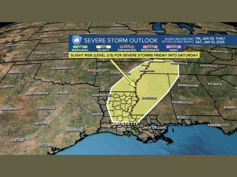
Storm Prediction Center Highlights Level 2 Severe Risk
The Storm Prediction Center (SPC) has placed areas of Acadiana north of Interstate 10 under a “Slight Risk” (Level 2 of 5) for severe storms in its Day 4 Outlook, signaling increased confidence that storms could organize as the cold front moves through.
Areas farther south across Acadiana may be included in a Marginal Risk (Level 1 of 5) in the Day 3 Outlook, meaning isolated severe storms remain possible, though widespread impacts are less likely.
A Level 2 risk typically supports:
- Strong thunderstorms
- Gusty, potentially damaging winds
- Heavy downpours
- Isolated severe weather impacts
Timing: Friday Into Friday Night
Forecast models suggest storms will begin to increase in coverage Friday, with the main line of weather pushing through Friday evening into Friday night as the cold front advances.
Model guidance shows:
- A well-defined rain and storm band
- Increasing wind fields along the front
- A transition to cooler air immediately after passage
While this is currently considered a low-end severe setup, meteorologists caution that confidence often increases closer to the event, especially when cold fronts interact with lingering Gulf moisture.
Weekend Outlook Turns Chilly and Damp
One notable change in the forecast is the potential for lingering light rain or drizzle to persist through much of the weekend. Instead of a quick clearing behind the front, cloud cover and light precipitation may linger, contributing to a gray, damp, and cooler pattern.
Temperatures are expected to:
- Drop into the 40s and 50s
- Remain below recent averages
- Create a chilly feel, especially with lingering moisture and light winds
This setup could make the weekend feel raw and uncomfortable, even without heavy rainfall.
What Residents Should Watch For
Residents across Acadiana should remain weather-aware, especially Friday afternoon and evening. Key points to monitor include:
- Updated SPC outlooks
- Any changes in storm intensity
- Wind advisories or localized warnings
- Wet roads and reduced visibility Friday night
Although this system does not currently indicate a high-end outbreak, low-end severe storms can still produce impactful weather, particularly when winds increase or storms train over the same areas.
Bottom Line for Acadiana
Acadiana faces a two-part weather impact: a Friday night storm risk tied to a strong cold front, followed by a cool, damp, and dreary weekend. While widespread severe weather is not guaranteed, conditions are favorable enough to warrant close monitoring, especially for communities north of I-10.
Stay with SaludaStandard-Sentinel.com for continued updates as confidence increases and timing becomes more refined.