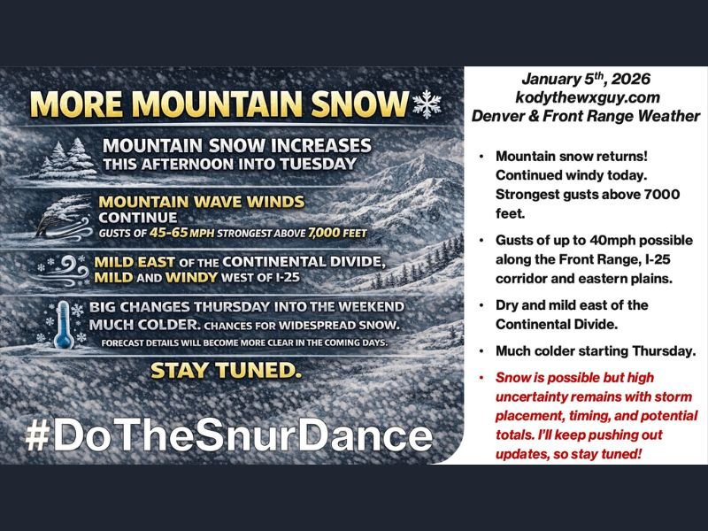
Colorado Faces Strong Mountain Winds, Increasing High-Elevation Snow, and Uncertain Winter Pattern Shift Later This Week
COLORADO — Strong winds and increasing mountain snowfall are shaping weather conditions across the state as a mountain wave pattern continues early this week. Forecast data shows powerful wind gusts at higher elevations, while snow coverage expands in the mountains through Tuesday and possibly into early Wednesday. Conditions remain dry and relatively mild east of the Continental Divide for now, but a pattern change is expected later this week behind an approaching cold front.
Mountain Wave Winds Create High-Impact Gusts
A persistent mountain wave setup is producing strong and potentially damaging wind gusts, particularly at higher elevations. Forecast guidance indicates gusts up to 65 mph above 7,000 feet, with gusts exceeding 40 mph possible along the Front Range, the I-25 corridor, and across the eastern plains, extending into parts of Nebraska and western Kansas. These winds may impact high-profile vehicles, mountain travel, and exposed areas, especially during peak gust periods.
Mountain Snow Increases Through Tuesday
Snow coverage in the mountains is expected to increase this afternoon, continue through Tuesday, and may linger into early Wednesday. Most locations will see modest accumulations, but higher elevations are favored for measurable snowfall.
Forecast totals suggest 1 to 3 inches mainly at and above 9,000 feet, including some mountain valleys where localized higher amounts are possible. Light accumulations may extend into foothill areas down to around 7,000 feet through midweek.
Heaviest Snow Targets Highway 40 Corridor
The highest confidence snowfall zone is along the Highway 40 corridor, particularly near Steamboat Springs and Rabbit Ears Pass. This area is expected to see 6 to 12 inches of snow, making it the most impactful location for winter travel during this event. Motorists traveling through these passes should be prepared for snow-covered roads and reduced visibility during periods of heavier snowfall.
East Of The Continental Divide Stays Dry And Mild
For locations east of the Continental Divide, conditions remain dry, mild, and windy, with only occasional passing clouds. Aside from gusty winds, no precipitation is expected in these areas through midweek, allowing for relatively stable conditions compared to the mountains.
Cold Front Brings Pattern Change Later This Week
A cold front arriving Thursday is expected to bring much colder temperatures across Colorado heading into the weekend. Between Thursday and Saturday, there is potential for additional snow across the region, but forecast confidence remains low regarding timing, placement, and snowfall totals.
Model guidance shows significant disagreement, meaning it is too early to determine who receives the heaviest snow or how impactful the system may become.
Looking Ahead: High Uncertainty Remains
Beyond the late-week system, ensemble data suggests another ridge of high pressure may rebuild into next week. If this occurs, it could limit the duration of colder, stormier conditions. However, winter patterns remain volatile, and updates will be necessary as trends become clearer.
Residents should stay aware of rapidly changing forecasts, especially those traveling through mountain corridors or planning outdoor activities later this week. SaludaStandard-Sentinel.com will continue tracking developments and provide updates as confidence improves.