Alabama, Georgia, and Mississippi Under Wind Advisory as Gusts Up to 45 MPH Expected Thursday and Friday
BIRMINGHAM, AL — Residents across Alabama, Georgia, and Mississippi are being warned to brace for strong, gusty winds expected to sweep through the region Thursday and Friday. Meteorologists say this system is “not just a breeze” — it’s a high-impact wind event capable of toppling unsecured objects, causing power disruptions, and making travel difficult across the Deep South.
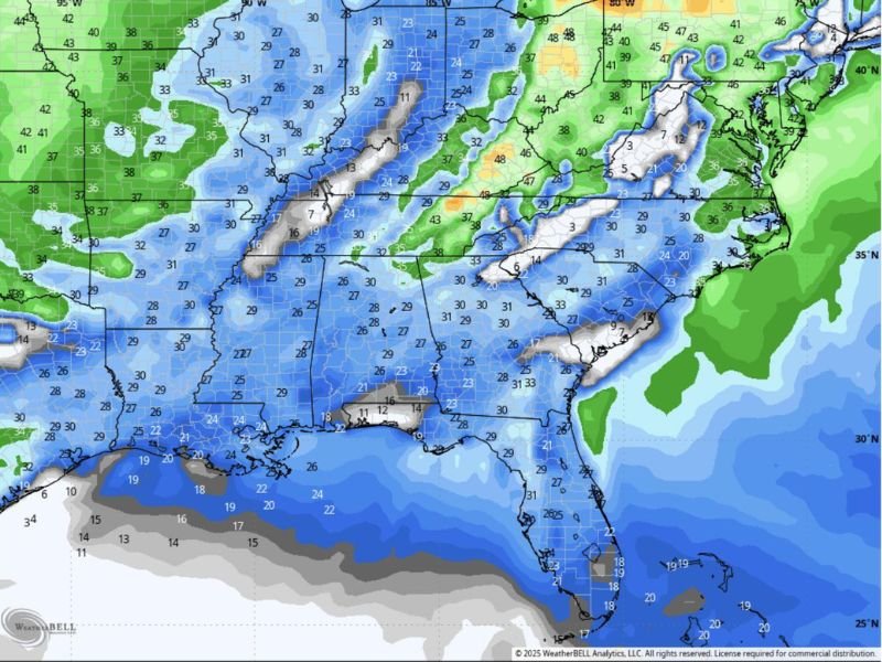
According to WeatherBell Analytics, widespread wind gusts between 30 and 45 mph are likely across central and northern Alabama, spreading eastward into Georgia and south into Mississippi and the Florida Panhandle by late Thursday night.
Strong Winds to Peak Thursday Afternoon
Forecasters say Thursday’s winds will be triggered by a powerful cold front moving across the Southeast. Behind it, cold, dry air will rush in — fueling northwest gusts strong enough to cause scattered power outages and tree damage.
“This isn’t the kind of wind that politely moves your hair,” one meteorologist joked. “It’s the kind that tests your wig glue and makes you rethink your parking lot walk.”
The wind pattern is expected to intensify Thursday afternoon through early Friday, before gradually weakening late Friday night.
Friday Brings More Gusts and Wind Chill
Friday’s forecast calls for temperatures in the 20s and 30s, with wind chills dipping even lower in elevated areas. Some parts of north Alabama and central Georgia could see gusts approaching 40–45 mph through the morning hours.
Weather models show the strongest wind zones stretching from Birmingham to Atlanta, with additional gusty conditions across Montgomery, Jackson, and Tupelo.
“By Friday morning, it’s the kind of weather where you hold your head down while walking and regret not tying your hat,” forecasters quipped. “This is FaceTime-unavailable weather.”
Travel and Power Concerns
The National Weather Service advises residents to secure outdoor decorations and trash bins, and to use caution while driving, especially for high-profile vehicles on open roads and bridges.
Loose tree limbs may come down, and minor power interruptions are possible.
The combination of strong winds and cooler air could also make outdoor conditions feel significantly colder — wind chills in the upper teens are possible across parts of north Alabama and central Mississippi.
What Residents Should Expect
- Peak gusts: 35–45 mph Thursday through Friday.
- Timing: Thursday afternoon through early Friday evening.
- Risks: Power outages, flying debris, and travel hazards.
- Temperatures: Falling into the 30s with colder air spreading eastward.
Officials recommend avoiding unnecessary outdoor activity during the peak gusts and keeping an eye on local alerts in case wind advisories are upgraded.
For continuous updates on severe weather and safety alerts across the South, follow SaludaStandard-Sentinel.com.