North Texas Braces for Overnight Thunderstorms Bringing Heavy Rain, Gusty Winds, and Lightning Friday Into Saturday
DALLAS, TEXAS — Residents across North Texas are being warned to prepare for overnight thunderstorms and heavy downpours beginning late Friday night and continuing into Saturday morning, as the next disturbance moves across the region.
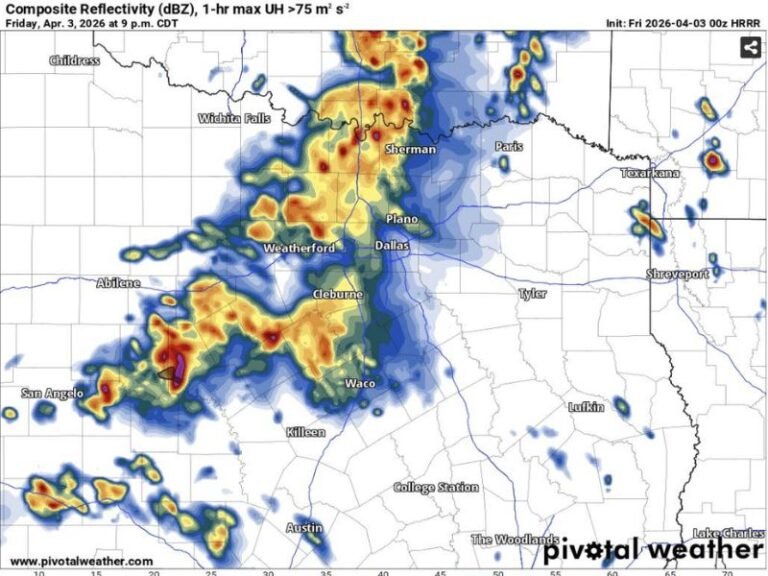
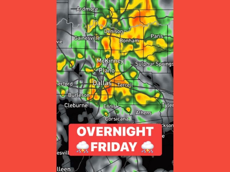
Meteorologists say data has remained consistent in showing the arrival of a fast-moving storm system that will deliver frequent lightning, gusty winds, and locally heavy rainfall to cities including Dallas, Plano, McKinney, Denison, and Gainesville.
Timing and Storm Details
According to the latest weather models, the main window for activity will stretch from midnight Friday through noon Saturday, with a potential for a second round of storms to develop later in the day as the cold front pushes through.
Heavy bands of rain are expected to pass directly through the Dallas-Fort Worth Metroplex, bringing short bursts of intense rainfall rates that could cause brief ponding on roadways and reduced visibility for drivers.
“Residents should expect lightning, strong wind gusts, and possibly small hail embedded within some of the stronger downpours,” forecasters said Friday. “While widespread severe weather isn’t anticipated, the storms will be noisy and fast-moving.”
Areas of Concern
The strongest storm activity is forecast to impact:
- Dallas County
- Collin County
- Denton County
- Grayson County
- Hunt and Kaufman Counties
Communities like Ennis, Corsicana, Tyler, and Athens could also see heavy rain during the early morning hours. Drivers traveling along I-35, U.S. 75, and I-20 should use caution during the overnight period, as slick roads and reduced visibility may occur.
Second Wave Possible Saturday Afternoon
While the main activity will occur overnight, weather experts note the possibility of additional storm development along the front Saturday afternoon as the boundary shifts south and east.
If daytime heating is sufficient, some storms could briefly intensify, though widespread severe conditions remain unlikely at this time.
“The setup supports a few stronger storms redeveloping during the afternoon, but the overall threat level looks low,” forecasters said. “Still, gusty winds and downpours can’t be ruled out.”
What Residents Should Do
Residents across North Texas are advised to:
- Secure outdoor furniture and decorations ahead of strong winds.
- Avoid driving through flooded intersections or areas with low visibility during heavy rain.
- Charge mobile devices and ensure weather alerts are enabled overnight.
- Monitor local forecasts for updates as the timing and intensity of the system are refined.
No widespread flooding is expected, but isolated urban flooding may occur in poor drainage areas due to the potential for repeated heavy downpours.
Looking Ahead
The cold front responsible for Friday night’s storms will usher in cooler, drier air by late Saturday, clearing skies by Sunday morning. Temperatures are expected to drop into the 40s overnight, with highs returning to the upper 50s and 60s through the remainder of the weekend.
Meteorologists continue to track the potential for additional systems moving into Texas early next week as an active late-November weather pattern persists across the South.
Stay with SaludaStandard-Sentinel.com for ongoing updates on North Texas weather alerts and weekend storm coverage.