Wintry Mix to Sweep Across Southern Plains Monday, Bringing Snow, Sleet, and Freezing Rain to Oklahoma, Arkansas, and North Texas
OKLAHOMA — A messy wintry system is expected to move across the Southern Plains on Monday and Tuesday, bringing a mix of snow, sleet, and freezing rain from Kansas and Oklahoma down into parts of Arkansas and North Texas, forecasters say.
While the system is not expected to be a major snowstorm, even light accumulations of snow or ice could create hazardous travel conditions through early Tuesday, particularly across eastern Oklahoma and northern Arkansas.
Snow, Sleet, and Ice to Impact Multiple States
The latest forecast models show a complex setup developing as cold air wraps around a passing low-pressure system. Depending on location, precipitation could start as rain or freezing rain before changing to sleet and light snow by late Monday.
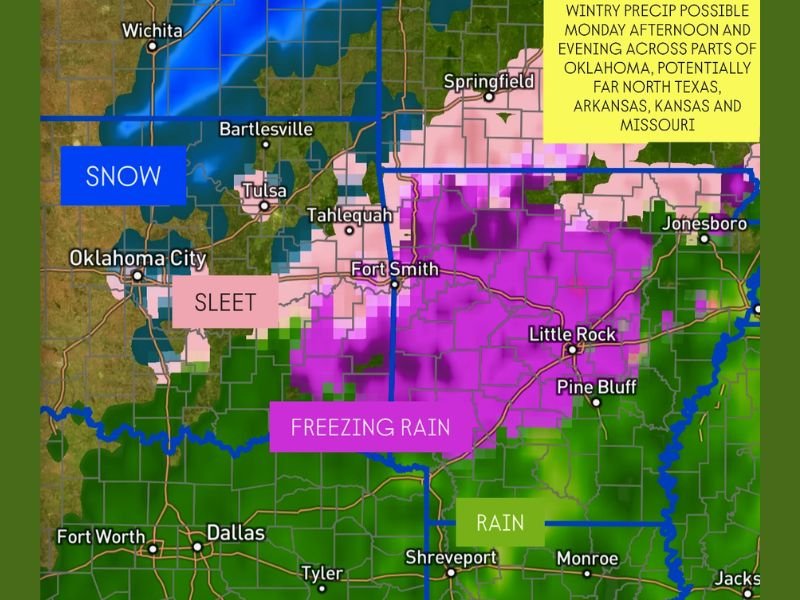
- Kansas is expected to see 1–3 inches of snow, with the heaviest amounts in the southeast portion of the state.
- Northern Oklahoma could see light snow and sleet accumulations, especially around Bartlesville, Ponca City, and Tulsa.
- Central and eastern Oklahoma, including areas around Fort Smith and Tahlequah, are more likely to experience a mix of freezing rain and sleet, potentially leading to light icing.
- Far southeastern Oklahoma and northern Arkansas could face a glaze of ice, making roads and bridges slick.
- North Texas, including the Dallas-Fort Worth region, will primarily see cold rain, but brief sleet mixing cannot be ruled out north of the metro.
Meteorologists note that the transition zone between snow and freezing rain will make precise accumulation forecasts difficult until the system fully develops.
Timing and Travel Concerns
Precipitation is expected to begin Monday afternoon, increasing in coverage through the evening. The heaviest period of wintry weather will likely occur between Monday evening and early Tuesday morning before tapering off.
The National Weather Service warns that even a thin glaze of ice could cause significant travel problems, particularly during the Monday evening commute and Tuesday morning rush hour.
“This won’t be a blockbuster winter storm, but we know from experience that even a small amount of snow or ice can cause major travel issues,” meteorologists said.
Drivers across Oklahoma, Arkansas, and southern Missouri are advised to check road conditions before traveling and keep an emergency kit in their vehicles.
Colder Air Locks in Behind the System
As the storm exits Tuesday, cold air will remain entrenched across the Southern Plains, keeping temperatures below freezing for much of the day. Highs will struggle to reach the mid-30s in Oklahoma and northern Arkansas, while areas farther south, such as Dallas and Shreveport, will warm slightly into the low 40s.
Wind chills will make conditions feel even colder, especially during the early morning hours.
Advisories Possible
Although no widespread warnings have been issued yet, the National Weather Service may release Winter Weather Advisories if models continue to show icing potential. Meteorologists say that even light freezing drizzle on untreated surfaces could lead to accidents and power disruptions.
Residents are urged to stay alert to forecast updates as models refine precipitation type and timing.
Stay connected with SaludaStandard-Sentinel.com for ongoing weather updates, road conditions, and advisories as this winter system moves through the Southern Plains.