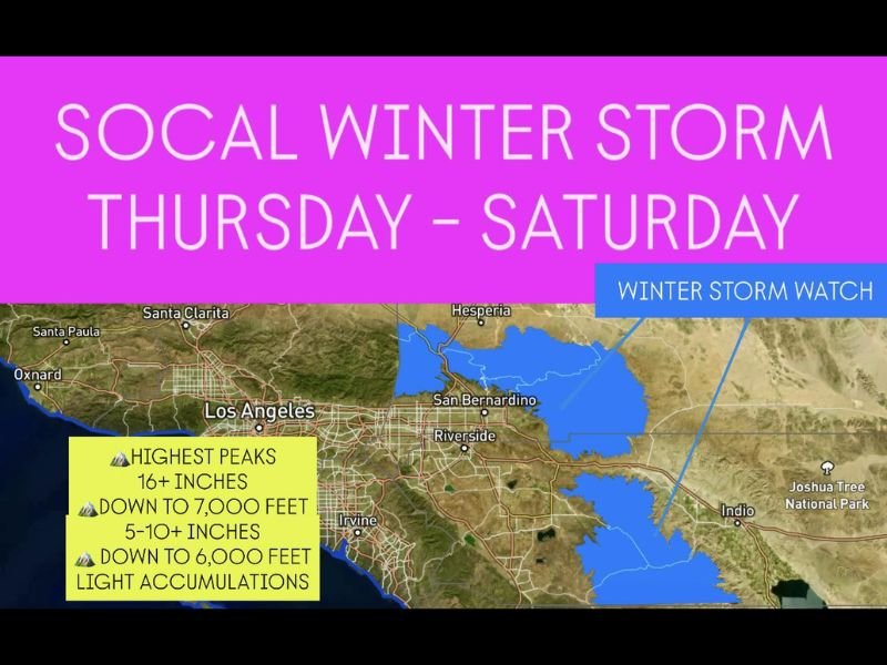
Winter Storm Watch Issued for Southern California Mountains as Major System Brings Heavy Snow
CALIFORNIA — The National Weather Service has issued a Winter Storm Watch for parts of Southern California’s mountain regions, where a major incoming storm is expected to drop significant snow accumulations beginning Thursday and continuing through Saturday.
Forecasters warn of hazardous driving conditions, possible road closures, and icy travel across mountain passes as the system intensifies.
Heavy Snow Expected at Higher Elevations
According to the latest forecast, snow will begin developing Thursday morning in the San Bernardino Mountains, San Gabriel Mountains, and other nearby ranges before spreading into Riverside and San Diego County mountains later in the day.
Expected snowfall totals include:
- 16+ inches on the highest peaks.
- 5–10 inches down to 7,000 feet.
- Light accumulations possible down to 6,000 feet.
The heaviest snow is anticipated between Thursday night and Friday evening, when colder air moves in behind the storm system.
Travel Impacts and Safety Concerns
Motorists planning to travel on I-15 through Cajon Pass, Highway 38, and Mountain High routes are urged to prepare for possible chain controls, low visibility, and slick road conditions.
Strong winds may accompany the snow, creating blowing and drifting snow at higher elevations.
“Travel could become very difficult to impossible in the mountains,” forecasters said. “Those with plans to drive into higher terrain should consider alternate routes or postpone travel.”
Rain for Lower Elevations
While snow will be confined to the mountains, rain showers are expected across Los Angeles, Ventura, Orange, and San Diego counties through the weekend. Forecasters predict up to one inch of rainfall in coastal and valley areas, with locally heavier totals possible.
Storm Timing and Duration
- Thursday Morning: Snow begins in mountain areas above 7,000 feet.
- Thursday Night into Friday: Heaviest snow and strongest winds.
- Saturday: Showers taper off, leaving cold, breezy conditions.
The storm is part of a broader Pacific system that will continue to bring unsettled weather to California into next week, including additional rain and potential snowfall at higher elevations.
Residents Urged to Stay Prepared
Officials encourage mountain residents and travelers to:
- Carry snow chains and emergency kits.
- Avoid unnecessary mountain travel during heavy snowfall.
- Stay updated through local alerts and the National Weather Service Los Angeles office.
Forecasters say the upcoming system marks the first significant mountain snow event of the season for Southern California — signaling the early arrival of winter across the region.
For continued weather updates and regional alerts, visit SaludaStandard-Sentinel.com.