Widespread Heavy Snow Risk Emerges for Late January as CPC Highlights Multiple Regions From the Rockies to the Northeast
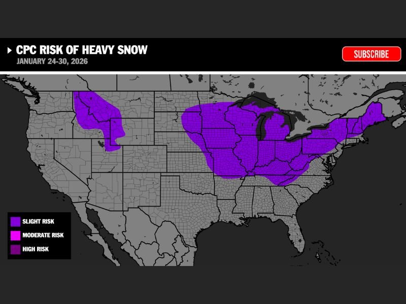
UNITED STATES — A broad zone of heavy-snow risk is taking shape for January 24–30, 2026, as new guidance from the Climate Prediction Center (CPC) highlights multiple regions across the country with elevated chances of impactful winter weather. The risk map displays a large corridor of potential heavy snow extending from the Northern Rockies through the Upper Midwest, into the Great Lakes, the Ohio Valley, and all the way through the Northeast.
CPC Map Highlights a Large Heavy-Snow Corridor
The map shows:
- A slight to moderate risk of heavy snow across the Northern Rockies, including portions of Montana, Idaho, and Wyoming.
- A large, continuous zone of heavy-snow risk stretching from the Dakotas, Minnesota, Wisconsin, and Iowa through Illinois, Indiana, Ohio, and parts of the Mid-Atlantic.
- An extension of the risk zone up through the Northeast, including heavy-snow potential across New York and New England.
These highlighted areas represent regions where CPC outlooks suggest an increased likelihood of impactful snowfall during the final week of January.
Midwest and Great Lakes Stand Out as Key Focus Areas
The central section of the map shows some of the most widespread coverage, with the Upper Midwest, Great Lakes, and Ohio Valley sitting squarely within the heavy-snow risk zone.
This includes major population centers and high-travel corridors that could be affected should one or more storm systems track through the region during the January 24–30 window.
Rockies Also Included in Heavy-Snow Zones
The risk map also identifies heavy-snow potential across the Northern Rockies, where terrain-driven snowfall events are common in late January. These regions appear shaded similarly, indicating that multiple storm setups could impact both mountainous and adjacent lower-elevation zones during the same period.
Northeast Also Highlighted for Late-January Snow Potential
The CPC outlook extends heavy-snow risk into portions of the I-95 corridor, the Appalachians, and states across the Northeast. This suggests the potential for winter storms to travel from the central U.S. into the eastern seaboard during the last week of January.
While the map does not predict exact storm tracks, it signals a pattern supportive of at least one impactful winter system.
Large-Scale Pattern Favoring Snow Across Multiple Regions
While no specific storm is shown in the graphic, the size of the highlighted zones points toward a winter pattern capable of producing multiple opportunities for heavy snow during January 24–30. The signal covers a significant stretch of the country, indicating a broad, active winter storm track as the month ends.
More details will emerge as shorter-range models refine individual storm systems. Residents across the highlighted regions can follow updates and share local conditions at SaludaStandard-Sentinel.com.