Washington, Oregon, California, Arizona, and Idaho Face Flooding Rains and Record-Breaking Heat as Pineapple Express Collides With Expanding Heat Dome
WASHINGTON — A powerful Pineapple Express system is delivering heavy rain and rising flood risks across Washington and Oregon, while at the same time a dangerous heat dome is shattering temperature records across California, Arizona, and parts of the Southwest.
This unusual coast-to-coast contrast is creating one of the most dynamic weather setups of the season, with flooding concerns in the Pacific Northwest and extreme heat gripping the southern half of the West.
Flood Warnings Intensify Across Washington Rivers
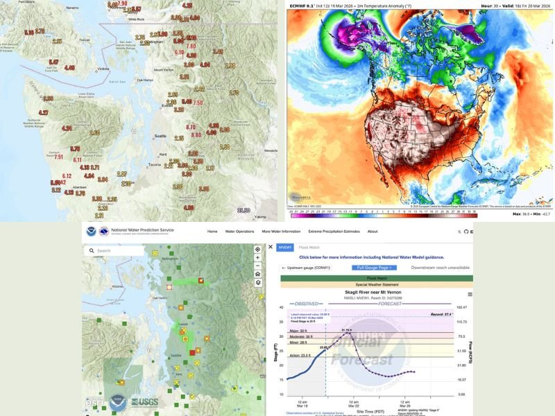
Multiple rivers across western Washington are now under Flood Warnings as days of steady rainfall continue to push water levels higher. The Skagit River is forecast to reach well into moderate flood stage, coming close to major flood thresholds in areas like Concrete and Mount Vernon.
The Snoqualmie River has already crested in moderate flood stage but is expected to fluctuate through the weekend as additional rain moves through. Similarly, the Snohomish River may briefly dip before rising again with the next wave of precipitation. Rivers such as the Skykomish and Tolt are also being closely monitored, with some locations expected to rise back above flood stage as runoff continues.
Olympic Rain Shadow Limits Seattle Impact but Mountains See Heavy Rain
While widespread rain is impacting much of Washington, areas around Seattle and Everett have seen less intense rainfall due to the Olympic Rain Shadow effect. This has led some lowland communities to experience lighter precipitation compared to surrounding regions.
However, the Cascades and nearby higher elevations have received significant rainfall, contributing heavily to rising river levels. Forecasters say the rainfall pattern has matched expectations in the mountains, where runoff is now feeding into already stressed waterways.
Final Day of Heavy Rain Before Brief Break
Friday is expected to be one of the rainiest days in this multi-day event, with continued precipitation and gusty winds as the storm system moves through. Although winds are not expected to reach damaging levels, they may add to already challenging conditions.
By late Friday, the Pineapple Express system is expected to weaken and shift out of the region, allowing conditions to gradually dry from north to south. The weekend will bring a temporary break, with only scattered showers expected across Washington and Oregon. Dryer conditions are forecast to hold into Monday before another, more typical Pacific system arrives early next week.
Southwest Heat Wave Shatters Records in Arizona and California
While the Pacific Northwest deals with flooding rain, the Southwest is experiencing a historic early-season heat wave. Phoenix has already reached 102 and then 105 degrees this week, nearing all-time April records and expected to climb even higher.
Forecasts indicate temperatures could reach 106 to 107 degrees in the coming days, with highs remaining above 100 degrees for at least a week. This is a dramatic departure from historical trends, where March rarely sees such extreme heat. Palm Springs has also broken records, hitting temperatures of 106 and 107 degrees, well above its previous March benchmarks.
Heat Dome Expected to Expand Toward the Plains
Meteorologists say the current heat dome will begin shifting eastward after peaking in Arizona and California, extending its influence into parts of the Plains.
Although the intensity may decrease slightly, the system is still expected to produce record-breaking daily highs across new regions. Long-range outlooks suggest another heat dome could redevelop in the following weeks, though potentially weaker than the current one. This expanding heat pattern could bring unusually warm conditions to additional states as spring progresses.
A Stark Weather Divide Across the Western United States
The simultaneous presence of flooding rains in Washington and extreme heat in Arizona highlights the dramatic contrasts shaping the current weather pattern across the western United States. From rising rivers and saturated ground in the Pacific Northwest to record-breaking temperatures in the desert Southwest, the region is experiencing two extremes at once.
As conditions evolve over the coming days, both flood risks and heat impacts will remain key concerns for millions of residents. For continued updates on this developing situation, visit SaludaStandard-Sentinel.com and share how these changing conditions are affecting your area.