Unseasonable January Heatwave Brings 70s and 80s Across Alabama, Georgia, Mississippi, and Florida as Winter Pattern Breaks Down
ALABAMA — A significant and unseasonable January heatwave is expected to develop across the Deep South next week, bringing spring-like temperatures well above normal for mid-winter. Forecast maps show a broad area of warm air spreading northward, allowing daytime highs to climb into ranges more commonly seen in March or April. This shift marks a temporary breakdown of the typical winter weather pattern, replacing cooler air with sustained warmth across much of the southern United States.
Winter Pattern Breaks Down Across the South
Meteorological data indicates that the region is entering a period where winter conditions temporarily step aside, allowing warm air to dominate for several consecutive days. This is not a brief warm spike but rather a pattern-driven event, meaning temperatures are expected to stay elevated rather than cooling quickly overnight.
The absence of reinforcing cold air from the north is playing a major role, enabling warmer air masses to settle across the South without interruption.
Widespread 70s Expected in Multiple States
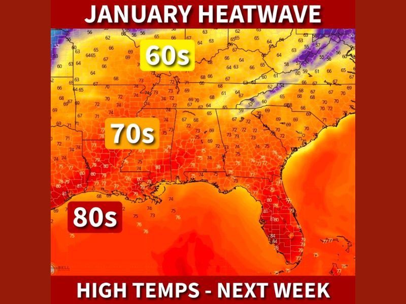
Large portions of Alabama, Georgia, Mississippi, and Louisiana are forecast to experience high temperatures in the 70s, a sharp contrast to average January conditions. Many inland areas that typically struggle to reach the 50s this time of year may instead feel mild and almost spring-like. These warmer conditions are expected to persist throughout the daytime hours, with temperatures remaining comfortably warm even after sunset.
80-Degree Heat Likely Near the Gulf Coast
The most intense warmth is expected closer to the Gulf Coast, where parts of southern Alabama, southern Mississippi, and Florida could see highs reaching the low to mid-80s. Forecast shading clearly shows deeper warm colors in these areas, indicating the strongest impact from the heatwave. Florida appears especially affected, with widespread warmth extending across much of the peninsula and limiting overnight cooling.
Northern Areas Still Warm, Just Less Extreme
Farther north, including parts of Tennessee and Kentucky, temperatures are forecast to remain slightly cooler than the Deep South but still well above seasonal norms. Many of these areas are expected to reach the 60s, which is still significantly warmer than typical January highs. This gradient highlights how expansive the warm air mass is, even though its strongest core remains farther south.
Why This January Warmth Stands Out
Extended warmth during January can disrupt normal seasonal expectations, influencing energy usage, outdoor activity, and even early plant growth. While this heatwave does not indicate that winter is over, it does represent a notable pause in colder conditions.
Forecast data currently shows no clear signal for an immediate return of winter-like temperatures through at least mid-January, though colder air could return later in the season.
What Residents Should Expect
Residents across the affected states should prepare for unseasonably warm afternoons, reduced heating needs, and weather that feels more like early spring than winter. Light clothing will be comfortable during the day, though evenings may still cool modestly. Despite the warmth, forecasters caution against assuming winter is finished, as seasonal patterns can shift quickly once this warm phase breaks down.
As shown clearly in the forecast imagery, this January heatwave is expected to impact a large portion of the Deep South, delivering an extended stretch of unusually warm weather before winter attempts to reassert itself later. Readers are encouraged to monitor local forecasts and share how warm conditions become in their area at SaludaStandard-Sentinel.com.