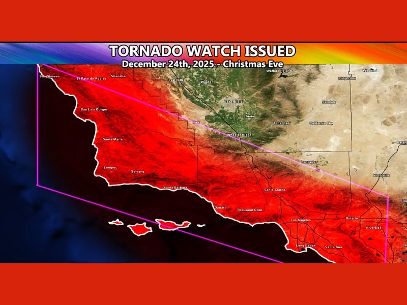
Tornado Watch Issued for Southern California as Christmas Eve Storm Brings Rare Severe Weather Threat
SOUTHERN CALIFORNIA — A powerful and unusually unstable storm system is prompting a Tornado Watch across multiple counties from late Monday night through Christmas Eve, with the potential for the watch to be extended into Christmas Day. Weather officials warn that atmospheric conditions resemble setups not seen in the region since the early 1980s, raising concerns about waterspouts, tornadoes, damaging winds, and intense thunderstorms.
Counties Included in the Tornado Watch
The Southern California Weather Force has placed the following areas under a Tornado Watch:
- San Luis Obispo County
- Santa Barbara County
- Ventura County
- Los Angeles County
- Orange County
- The Inland Empire, including portions of Riverside and San Bernardino counties
Officials say the watch covers both coastal and inland zones, where shifting wind patterns and warm low-level temperatures are creating dangerous instability.
Why This Storm System Is So Unusual
Meteorologists say this setup is far from typical for late December in California. Atmospheric dynamics indicate:
- Strong southerly flow bringing warm low-level air
- Significant low-level wind shear, a key ingredient for tornado development
- Highly unstable air, rarely seen in Southern California during the holiday season
Experts note that these ingredients together resemble the pattern observed in March 1982, one of the last times a similar tornadic profile developed in the region.
Christmas Eve Storm Details
A powerful cold front is expected to sweep across the region on Christmas Eve. Forecasters warn the front could generate:
- Waterspouts along the coast
- Tornadoes forming farther inland
- Severe thunderstorms with damaging wind gusts
- Heavy rainfall in a short period of time
The greatest risk is expected during the overnight and early-morning hours when the front begins shifting across coastal counties and moving inland throughout the day.
Christmas Day Could Bring a Second Round of Storms
While the initial Tornado Watch is focused on Christmas Eve, meteorologists say the threat may not end there. Colder air aloft will filter into the region on Christmas Day, increasing atmospheric instability. This second round of storms could bring:
- Stronger thunderstorms than the Christmas Eve event
- Renewed potential for isolated tornadoes
- Hazardous winds especially for high-profile vehicles
- Dangerous conditions near areas prone to flooding
The Southern California Weather Force says it is prepared to reissue or extend the watch if conditions intensify.
What Residents Should Do
Officials urge residents throughout Southern California — especially those in coastal and valley communities — to:
- Monitor weather alerts closely
- Avoid parking vehicles near large trees or unstable structures
- Prepare for sudden strong winds and brief tornado-like circulation
- Keep cell phones charged and emergency plans ready
Emergency managers also emphasize that even brief, weak tornadoes can cause structural damage and pose serious risk.
More Updates Coming
Meteorologists at Southern California Weather Force say they will continue monitoring the evolving system and issue further guidance as necessary. With two potentially dangerous storm waves approaching, residents across Los Angeles, Orange County, Ventura, Santa Barbara, San Luis Obispo, and the Inland Empire are encouraged to stay alert through Christmas Day. Stay with SaludaStandard-Sentinel.com for ongoing weather coverage and official updates as this severe holiday storm continues to develop.