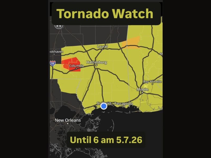
Tornado Watch Extended South to Cover All of South Mississippi Until 6 AM With Active Storm Cell Threatening Columbia, Hattiesburg and Gulf Coast Communities on May 7
GULFPORT, MS — A Tornado Watch has been expanded southward to now include all of South Mississippi, with the watch remaining active until 6:00 AM on May 7, 2026, as dangerous storm conditions continue pushing through the region and threatening densely populated Gulf Coast communities overnight.
Watch Extended to Cover Entire Southern Mississippi
Authorities extended the existing Tornado Watch boundary southward to capture all remaining portions of South Mississippi not previously included in the watch zone. The expansion reflects rapidly evolving atmospheric conditions across the region, with meteorologists tracking the storm system as it advances toward coastal communities including Gulfport and Pascagoula, bringing heightened tornado risk to areas that had not initially fallen within the watch perimeter.
Active Storm Cell Near Columbia
Radar data shows a particularly concerning storm cell actively developing near Columbia, Mississippi, situated in the western portion of the watch zone along the Interstate 55 corridor. The cell, marked by intense returns on First Alert Weather radar, poses an immediate threat to surrounding communities in Marion and surrounding counties. Residents in and around Columbia are urged to treat this situation with the highest level of urgency and seek shelter immediately if warnings are issued for their specific location.
Communities Across South Mississippi at Risk
The expanded watch zone now places major South Mississippi population centers including Hattiesburg, Laurel, Gulfport, and Pascagoula under elevated threat through the early morning hours. The broad geographic coverage of this watch underscores the widespread nature of the severe weather event, as storm conditions remain favorable for tornado development across multiple counties simultaneously throughout the southern tier of the state.
Residents Urged to Stay Alert Through Early Morning
With the watch running through 6:00 AM, residents across all of South Mississippi face several hours of continued overnight danger. Weather officials strongly advise keeping emergency alert systems activated, avoiding sleep without a reliable warning system in place, and knowing the location of the nearest interior shelter well in advance of any tornado warning being issued in the area.
For continuing coverage of severe weather events and critical storm analysis across the United States, visit SaludaStandard-Sentinel.com.