Texas, Oklahoma, Missouri, Illinois, Indiana, Ohio, Pennsylvania and New York Face Repeated Heavy Rain Bands With Flood Risk Rising Through Weekend
UNITED STATES — A developing weather pattern is setting up a long corridor of heavy rainfall stretching from Texas through the Midwest and into the Northeast, with repeated rounds of storms expected to move over the same areas through the weekend.
Forecasters indicate that this setup could lead to significant rainfall totals in localized zones, especially where storms repeatedly track along the same path, increasing the potential for flooding concerns.
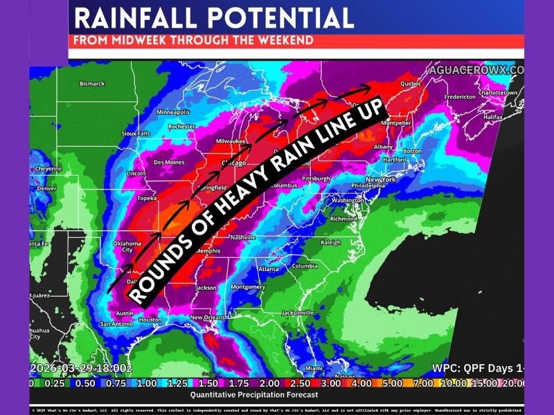
Storm Track Aligns From Southern Plains to Northeast Corridor
The latest rainfall projections show a clear and consistent storm path extending from Texas through Oklahoma, Missouri, Illinois, Indiana, Ohio, Pennsylvania, and into New York.
This alignment is critical because it means storms are not scattered but instead following a repeated route. Areas under this corridor are more likely to see multiple rounds of rain rather than a single system passing through.
This type of pattern is commonly associated with “training storms,” where rain bands move over the same locations again and again, significantly increasing total rainfall.
Multiple Waves of Rain Expected Over the Same Areas
Rainfall in this setup will not fall all at once but instead arrive in waves over several days. Each round may bring moderate to heavy rain, but the cumulative totals could become significant.
Forecast data suggests that several inches of rain are possible within this corridor, especially where the heaviest bands—highlighted by deeper reds and purples—line up. Because these waves are spaced out, the ground may remain saturated, allowing water to build up quickly with each additional round.
Flooding Concerns Increase in Repeated Storm Zones
Flood risk becomes more concerning when storms repeatedly impact the same areas. Even if individual storms are not extreme, repeated rainfall can overwhelm drainage systems.
Urban locations, flood-prone zones, and areas near rivers or streams could see rising water levels if rainfall totals increase rapidly. Not every location will experience the worst impacts, but areas directly under the heaviest rain bands could see flooding develop in a short amount of time.
Small Shifts in Storm Track Could Change Impact Areas
One key factor in this setup is how the storm track shifts over time. Even a slight movement north or south could change which regions receive the heaviest rainfall.
This means forecasts may evolve day by day, and areas currently outside the main corridor could still be impacted if the track shifts. Residents across the central and eastern U.S. should stay alert to updates as the system develops.
Rainfall Distribution Will Be Uneven Across Regions
Despite the widespread setup, not all areas will see the same amount of rain. Some locations may receive lighter totals, while others just miles away could experience significantly heavier rainfall.
This uneven distribution is typical of training storm patterns, where narrow corridors of intense rain create sharp contrasts across nearby regions. Those within the main corridor should remain weather-aware as repeated storms continue through the week. Stay informed and share your local conditions or concerns by visiting SaludaStandard-Sentinel.com.