Texas, Oklahoma, Kansas, Arkansas and Louisiana Could See Big Severe Storm and Tornado Threat Surge From Late March Into Mid April
UNITED STATES — A growing signal in long-range weather models is pointing toward an increased risk of severe storms and possible tornado activity across parts of the Southern Plains and lower Midwest as the calendar turns from late March into early April.
Forecast guidance suggests a developing pattern that could support multiple rounds of storm activity, particularly across Texas, Oklahoma, Kansas, Arkansas, and Louisiana.
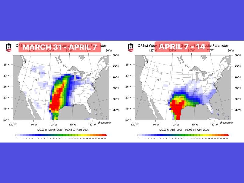
Model Trends Show Expanding Severe Weather Corridor
Recent model projections highlight a corridor of heightened storm potential stretching from Texas northward into Oklahoma and Kansas, with additional impacts extending east into Arkansas and Louisiana.
The first window, spanning late March into early April, shows a concentrated zone of activity across the central Plains. A second period into mid-April shifts the focus slightly south and east, reinforcing the threat across the southern Plains and Gulf-adjacent states. This evolving pattern indicates a broad area of concern rather than a single isolated event.
Pattern Setup Favors Storm Development During Peak Season
Meteorologists are closely watching what appears to be a developing trough-and-ridge pattern. This setup can enhance atmospheric instability and wind dynamics, both of which are key ingredients for severe storm formation.
As seasonal conditions continue to transition into spring, the environment becomes more favorable for strong thunderstorms capable of producing damaging winds, large hail, and potentially tornadoes. This pattern alignment is occurring during a time of year when severe weather activity typically begins to ramp up across the Plains.
Texas and Oklahoma Could Be Early Focus Areas
The earliest and most consistent signals for storm development appear centered across Texas and Oklahoma. These states could see the initial rounds of activity as the pattern begins to take shape.
Storms in these regions may organize into larger systems capable of producing widespread impacts, particularly if instability and wind shear align. Given the history of severe weather in these areas during spring, even early-season setups are taken seriously by forecasters.
Threat May Expand Into Surrounding States by Mid-April
As the pattern evolves, the risk area may broaden to include parts of Arkansas, Louisiana, and potentially neighboring regions. This expansion suggests that multiple states could experience periods of unsettled and potentially severe weather conditions.
While the exact timing and intensity of individual storms remain uncertain at this range, the consistency across multiple model runs increases confidence in a more active period ahead. Residents across these regions should remain aware of updates as the forecast becomes more refined.
Long-Range Outlook Signals Potentially Active Start to Spring
Although this is not a short-term forecast, the long-range signals are strong enough to raise early awareness. This type of setup has historically been associated with increased severe weather activity during spring.
Forecasters emphasize that details will continue to change, but the overall trend points toward a potentially active start to April across the Southern Plains. Preparedness and attention to future forecasts will be important as this pattern develops.
Are you located in one of these states and preparing for storm season? Share how you’re getting ready or what conditions you’re seeing by visiting SaludaStandard-Sentinel.com.