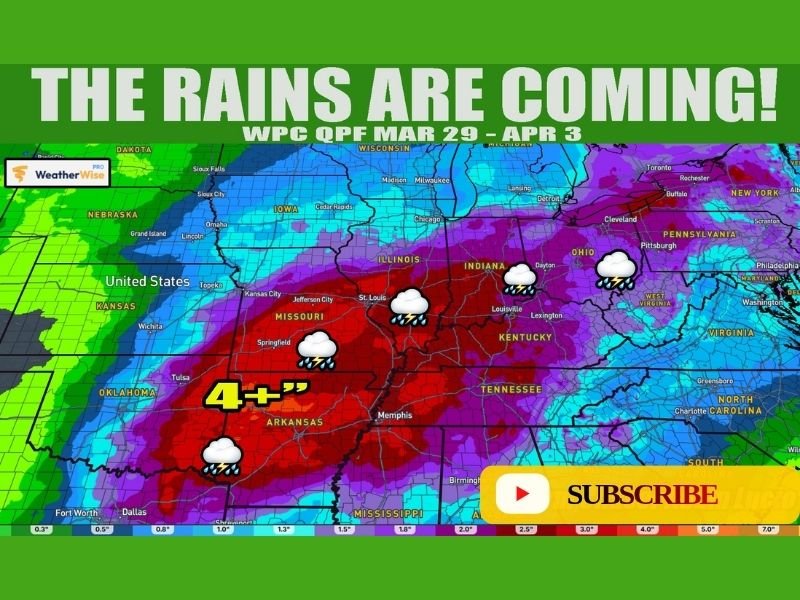
Texas, Oklahoma, Arkansas, Missouri, Illinois, Indiana, Kentucky and Tennessee Brace for Widespread Heavy Rainfall With 4+ Inches Expected Early April
UNITED STATES — A major shift toward a wetter weather pattern is expected to take hold across the central United States as the calendar turns to April, bringing widespread rainfall that could total more than 4 inches in some areas.
Forecast models show a broad corridor of heavy precipitation developing from Texas and Oklahoma through Arkansas, Missouri, Illinois, Indiana, Kentucky, and Tennessee between late March and early April.
Heavy Rain Band Sets Up Across Central States
The latest precipitation outlook highlights a concentrated zone of significant rainfall stretching from the Southern Plains into the Ohio Valley.
Areas across Arkansas, Missouri, and parts of Kentucky and Tennessee are expected to see some of the heaviest totals, with rainfall exceeding 4 inches in localized zones. Surrounding states, including Texas and Oklahoma, are also expected to receive beneficial rainfall, though amounts may vary.
This setup indicates a sustained period of active weather rather than a single storm event, increasing the potential for cumulative rainfall totals to rise.
Drought Relief Expected in Southern Plains
Much of Texas, Oklahoma, and Arkansas has been experiencing developing drought conditions in recent weeks. The incoming pattern is expected to provide meaningful relief by delivering steady and repeated rounds of rain.
While not all areas will receive uniform totals, the widespread nature of the system should help improve soil moisture levels and reduce drought intensity across the region. Meteorologists note that continued activity beyond early April could further enhance these benefits if the pattern persists.
Storm Track Extends Into Midwest and Ohio Valley
Beyond the Southern Plains, the storm system is expected to track northeast into the Midwest and Ohio Valley, bringing additional rainfall to states such as Illinois, Indiana, and Kentucky.
These regions could see moderate to heavy rainfall totals, especially where storms repeatedly track over the same areas. The extended reach of the system underscores the large-scale nature of this weather pattern. Rainfall in these areas may also contribute to rising river levels depending on local conditions.
Active Pattern Likely to Continue Beyond Early April
Forecasters indicate that this initial wave of rainfall is only part of a broader, more active weather pattern expected to continue into early April and possibly beyond.
As additional systems move through, rainfall totals could increase further, particularly in regions already highlighted for heavier precipitation.
This continued activity may help reinforce drought relief but could also introduce concerns about localized flooding if rainfall becomes excessive.
Transition to Wetter Pattern Signals Seasonal Shift
The incoming pattern reflects a seasonal transition toward more frequent storm systems typical of early spring. Warmer air interacting with incoming disturbances often leads to increased precipitation across large portions of the country.
This shift marks a departure from recent drier conditions in several key regions and highlights the dynamic nature of spring weather across the United States.
Residents in affected areas are encouraged to monitor forecasts as rainfall totals may change with evolving conditions. Are you seeing drought conditions improve or expecting heavy rain in your area? Share your local updates and experiences with us at SaludaStandard-Sentinel.com.