Texas, Oklahoma, and New Mexico Face High Wildfire Outbreak Risk Wednesday as Humidity Drops Below 10% and Gusts Hit 35–50 MPH
TEXAS, OKLAHOMA, NEW MEXICO — Another dangerous fire weather day is shaping up for Wednesday across the Southern High Plains, where existing fires may burn overnight and then ramp back up by early afternoon as winds increase and humidity crashes. The outlook warns that an outbreak of wildfires is possible if sparks are introduced into the dry, windy environment—especially in open country where grass fires can run fast and spread far in minutes.
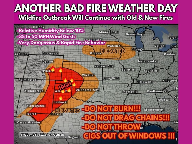
Why Wednesday’s Fire Weather Setup Is So Dangerous
The forecast highlights three ingredients coming together at the same time:
- Relative humidity below 10%, which dries out grasses and brush to the point where they can ignite easily
- Wind gusts in the 35 to 50 mph range, which can turn a small fire into a fast-moving wall of flames
- Rapid, unpredictable fire behavior, making containment difficult and increasing risk to people, property, and responders
Even if firefighters make progress overnight, the return of stronger winds during the day can undo those gains quickly, especially when fuels are already primed.
Where the Highest Wildfire Risk Is Concentrated
The “HIGH” risk zone is centered across parts of the Texas Panhandle and nearby areas, including the corridor around Amarillo and Lubbock, with elevated fire weather conditions extending outward into surrounding portions of the region. These zones are the most vulnerable to quick blowups because wind-driven fires in the High Plains can spread rapidly across flat, open terrain with few natural barriers.
Midwest Also Marked for Elevated Fire Weather Conditions
In addition to the Southern High Plains threat, the forecast also flags elevated fire weather conditions across parts of the Midwest, including an area highlighted near the Omaha to Waterloo corridor. While this is not shown as the highest category, it is still a warning that dry air and wind can support fast-moving grass or field fires—especially in rural areas and along roadways.
What Officials Warn Can Spark New Fires
The outlook strongly emphasizes avoiding common ignition sources during peak conditions, including:
- Do not burn yard debris or trash
- Avoid dragging chains or equipment that could throw sparks
- Never discard cigarettes outdoors, especially from vehicles
- Use extra caution around powerlines and any activity that could create a spark
These are the kinds of small triggers that can lead to multiple new fire starts when humidity is extremely low and winds are strong.
What to Watch for Through Wednesday Afternoon
The most dangerous window typically develops when daytime mixing increases winds and dries the air further—often late morning through afternoon. If you live in or travel through the highlighted areas, be ready for quickly changing conditions, reduced visibility near smoke, and possible road impacts if new fires develop.
What are you seeing where you live—smoke, burn bans, or firefighting activity already underway? Share what you’re noticing and join the conversation at SaludaStandard-Sentinel.com.