Texas, Oklahoma, and Arkansas Enter More Active Late-Winter Pattern as Jet Stream Strengthens and Southern Storm Track Wakes Up
UNITED STATES — A noticeable shift is underway in the upper-level atmospheric pattern, signaling a transition from a relatively quiet winter toward a more active late-winter and early-spring setup across large portions of the central and southern United States.
Meteorologists note that the longwave pattern is beginning to stretch, the jet stream is intensifying, and the southern branch of the jet is becoming more active — a combination that often precedes a more dynamic storm pattern.
Upper-Level Pattern Begins to Flip the Seasonal Switch
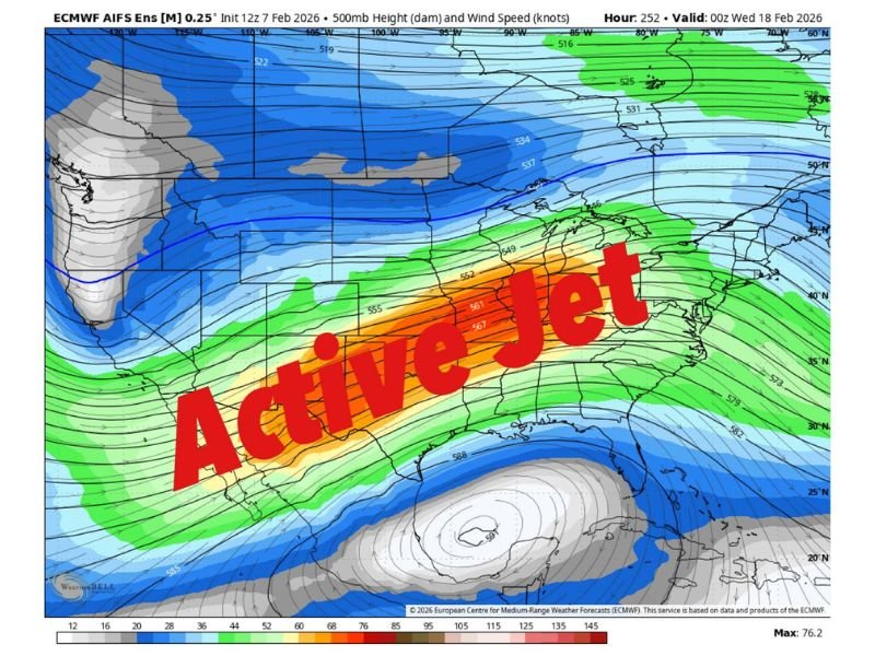
Forecast data shows a classic 500-millibar setup that frequently marks the transition from stagnant winter conditions to a period of increased storm activity. The strengthening jet stream is becoming louder and more energetic, allowing disturbances to eject more freely out of the western United States.
This type of configuration often acts as the atmospheric “switch” that opens the door to stronger and more frequent storm systems.
Southwest Flow and Pacific Energy Increasing
A strengthening southwest flow aloft is helping inject Pacific energy into the southern Plains, while a more defined storm track is beginning to establish itself from Texas into the Mid-Mississippi Valley.
At the same time, colder air lingering just to the north is sharpening temperature boundaries, creating a more favorable environment for stronger fronts and organized storm systems.
Severe Weather Pattern Not Locked In Yet
While the evolving pattern does not guarantee a specific severe weather event, meteorologists emphasize that the background environment is becoming increasingly supportive of stronger storms.
As Gulf moisture eventually returns northward, this setup could support better wind fields, sharper frontal zones, and a rising potential for thunderstorms and severe weather.
A Common Precursor to Early-Season Severe Weather
Historically, this type of upper-air pattern often precedes the first meaningful severe weather opportunities of the season, particularly across Texas, Oklahoma, Arkansas, and the Mid-South.
The atmosphere is beginning to show signs that it wants to become more active, even if the exact timing and impacts remain uncertain.
Quiet Winter Pattern Coming to an End
Forecasters say the takeaway is not alarm, but awareness. The quiet, suppressed winter pattern that dominated earlier weeks is starting to loosen its grip, making room for a more energetic and changeable weather regime.
Each system will be monitored closely as it ejects into the central and southern United States in the coming weeks.
What changes are you already noticing where you live? Share your observations and join the discussion at SaludaStandard-Sentinel.com, where we continue tracking major pattern shifts and developing weather threats across the country.