Texas Hill Country Faces Slight Severe Risk Sunday Afternoon as Less Morning Rain Could Allow Dangerous Supercells to Fire Across Central Texas
TEXAS — A critical and unusual weather relationship is shaping Sunday’s severe storm potential across Central Texas, where the amount of morning rainfall will directly determine how dangerous the afternoon storm threat becomes. The Storm Prediction Center has issued a level 2 out of 5 Slight severe risk for the Hill Country and a level 1 out of 5 Marginal severe risk for the Austin area and points east, with supercell development possible during the afternoon hours if morning clouds and rain clear sufficiently across the region.
Less Morning Rain Means Higher Afternoon Severe Risk
The key factor driving Sunday’s severe weather potential across Central Texas is a straightforward but important atmospheric dynamic. Morning clouds and rainfall naturally consume available storm energy, suppressing the instability needed for severe storm development later in the day. However, if morning precipitation remains limited and skies partially clear heading into the afternoon, that preserved energy becomes available to fuel potentially dangerous supercell thunderstorms.
Forecasters are watching this setup closely across the Hill Country and surrounding areas, where the balance between morning cloud cover and afternoon clearing will ultimately determine how significant the severe weather threat becomes during the peak afternoon hours.
Hill Country Under Level 2 Slight Severe Risk
The Storm Prediction Center has placed the Texas Hill Country under a level 2 out of 5 Slight severe risk for Sunday, reflecting a real but conditional threat for severe storm development during the afternoon. Communities across the Hill Country including Fredericksburg, Llano, Mason, Blanco, Burnet, and Lampasas fall within this elevated risk zone.
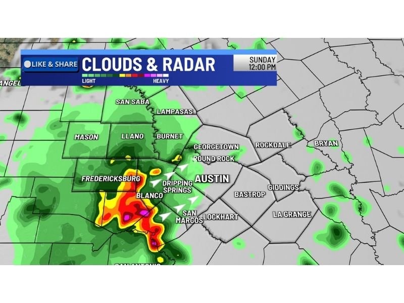
Radar imagery as of Sunday noon shows the heaviest precipitation already concentrated in a corridor from Fredericksburg through Blanco and toward San Marcos, with intense storm cores visible over the Hill Country region. Residents across these communities should remain weather aware throughout the afternoon hours.
Austin Area and East Under Marginal Severe Risk
East of the Hill Country, the Austin metropolitan area and communities further east including Round Rock, Georgetown, Dripping Springs, San Marcos, Lockhart, Bastrop, Rockdale, and Giddings fall under a level 1 out of 5 Marginal severe risk. While lower than the Hill Country threat, a Marginal risk still means isolated severe storms are possible and residents should not dismiss the threat entirely.
Even within a Marginal risk zone, a single supercell can produce large hail, damaging winds, or brief tornado activity if atmospheric conditions align favorably during the afternoon clearing window.
Residents across Central Texas are urged to monitor local forecasts closely through the afternoon and have a way to receive severe weather alerts quickly if storm conditions escalate across the region. Stay weather aware and share your storm reports at SaludaStandard-Sentinel.com.