Texas and Oklahoma Braces for Heavy Rain, Flooding, and Severe Weather as Active Storm Pattern Develops Before Thanksgiving
CENTRAL UNITED STATES — A powerful and active weather pattern is expected to develop across the central U.S. next week, bringing rounds of rain, thunderstorms, and potential flooding through the beginning of Thanksgiving week.
According to new precipitation forecasts, a broad storm system will set up from Texas to Missouri, drawing in Gulf moisture and producing several inches of rainfall. Forecasters are cautioning residents in low-lying and flood-prone areas to prepare for localized flooding and severe weather risks as the system intensifies.
Forecast Shows Widespread Rainfall Across Multiple States
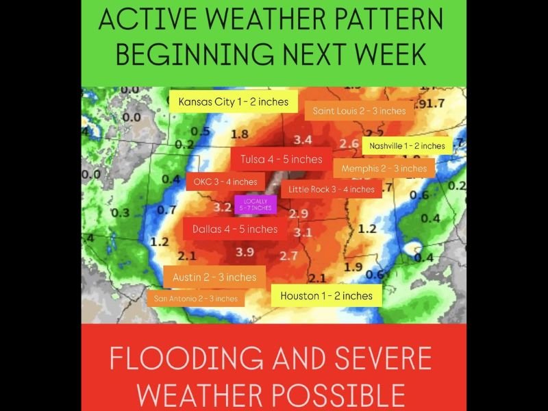
The weather map shows the heaviest rainfall totals centered over northern Texas, eastern Oklahoma, and western Arkansas, with 4 to 5 inches of rain possible in cities like Dallas, Tulsa, and Oklahoma City. Some areas could see localized totals between 5 and 7 inches, depending on storm training and the speed of the system.
Further north, Kansas City and Nashville could see between 1 to 2 inches, while Little Rock, Memphis, and St. Louis are forecast to receive 2 to 4 inches of rain through next week.
Meteorologists say the rainfall pattern will evolve as a strong jet stream interacts with an upper-level low, enhancing lift and producing multiple rounds of thunderstorms across the southern plains and lower Mississippi Valley.
“Flooding and severe weather are both possible with this setup,” forecasters warned. “Moisture levels will be unusually high for mid-November, making this a concerning storm for the days leading up to Thanksgiving travel.”
Areas Most at Risk
Regions across eastern Texas, Oklahoma, Arkansas, and Louisiana are expected to experience the heaviest rainfall and the highest flood risk. The National Weather Service is monitoring potential flash flooding hazards, especially in urban areas and along rivers and creeks.
- Dallas–Fort Worth, TX: 4–5 inches of rain expected
- Oklahoma City, OK: 3–4 inches, with locally higher amounts
- Tulsa, OK: 4–5 inches
- Little Rock, AR: 3–4 inches
- Austin and San Antonio, TX: 2–3 inches
- Memphis, TN: 2–3 inches
Thanksgiving Travel Impacts Possible
The system could cause disruptions to Thanksgiving travel, especially for those driving across interstates such as I-35, I-40, and I-44, where heavy rain may lead to reduced visibility and hazardous road conditions.
Additionally, forecasters are monitoring for severe storm potential, including strong winds and isolated tornadoes, particularly across Texas and Oklahoma where instability may increase.
“Motorists traveling through the Central Plains early next week should plan for longer drive times and possible detours due to flooded roadways,” weather officials advised.
Pattern Expected to Continue Into Thanksgiving Week
This storm system marks the start of an active late-November weather stretch, which could continue into Thanksgiving week with additional waves of rain and possible snow further north.
While the storms will help alleviate drought conditions in parts of the southern Plains, forecasters note that too much rain in a short time span could lead to dangerous flash flooding.
Outlook for the Following Week
As the Thanksgiving holiday approaches, the storm track is expected to shift eastward, potentially bringing rain and storm chances into portions of the Ohio Valley and Southeast. The overall weather setup suggests continued wet conditions for much of the central U.S. through the end of the month.
Stay tuned to SaludaStandard-Sentinel.com for the latest weather alerts, travel updates, and forecasts as Thanksgiving week approaches.