Spring Hint for Late February and Early March as Much of the U.S., Including Michigan, Trends Warmer Than Average
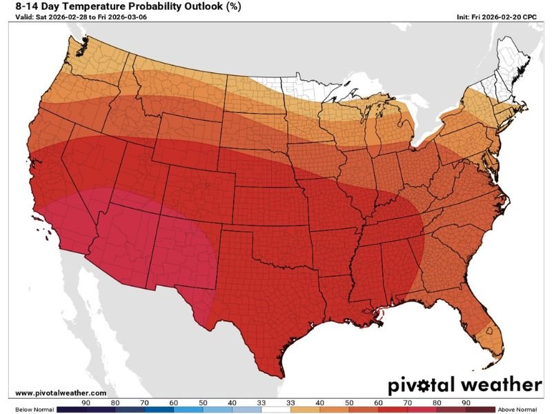
UNITED STATES — A fresh national temperature outlook is offering some early “spring tease” for late February into early March, showing above-average temperature probabilities across much of the country — including Michigan. The 8–14 day forecast window covers Feb. 28 through March 6, and suggests a broader warm-leaning pattern that could translate into more manageable daytime highs in areas that have been stuck in the deep-freeze.
For cold-weather states like Michigan, the warm signal doesn’t mean shorts-and-t-shirts. But it can mean a noticeable step up from bitter cold, with highs more frequently landing in the upper 30s to mid 40s, especially during the late-month transition into March.
What the 8–14 Day Temperature Outlook Is Signaling
The Climate Prediction Center’s temperature probability outlook highlights a wide swath of the nation leaning toward above-normal temperatures during the valid period. The strongest warm probabilities are focused across large portions of the southern and central United States, while the above-average shading also stretches into parts of the Midwest and Great Lakes region.
Michigan is included in that above-average zone, suggesting the state could see more days where temperatures run milder than typical for the time of year, even if winter weather remains possible.
What “Above Average” Could Look Like in Michigan
For many Michigan communities, the practical takeaway is that this pattern may support highs closer to late-winter thaw territory rather than repeated deep-freeze afternoons. The outlook discussion tied to the forecast suggests daytime highs could commonly reach the upper 30s into the mid 40s, which can help with daytime travel conditions and make outdoor errands less punishing.
However, it’s important to remember that above average doesn’t equal snow-free. Overnight lows can still dip below freezing, which keeps the risk of refreeze on untreated roads and sidewalks.
Why This Matters for Travel and Daily Planning
A warmer-leaning stretch can reduce prolonged extreme cold impacts, but it can also introduce a different set of issues: melting by day and refreezing at night, slushy side streets, and slick early-morning commutes. Drivers should still stay alert for black ice during the overnight and pre-dawn hours, especially in shaded areas and on bridges.
Are you seeing signs of an early thaw where you live, or are you still locked into winter conditions? Share what temperatures are doing in your area and what you’re hoping for next at SaludaStandard-Sentinel.com.