Southern Winter Storm Signal Strengthens as EURO Ensembles Show High Confidence in Snow and a Growing Ice Storm Threat
UNITED STATES — Confidence is increasing that a high-impact winter storm could affect large portions of the southern and eastern United States this weekend, as the latest EURO AI ensemble data shows unusually strong agreement among models — a key red flag for forecasters.
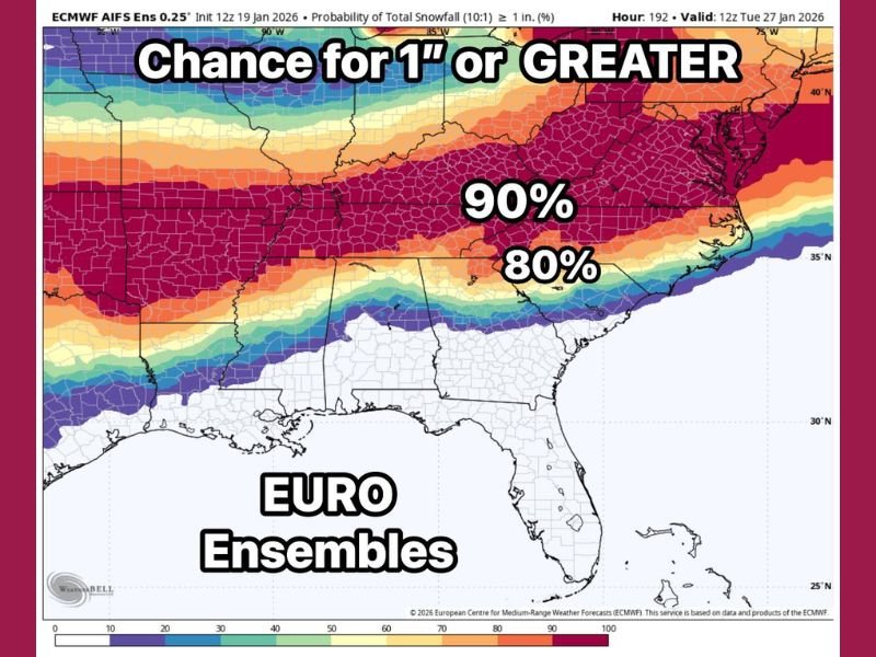
According to the latest guidance, there is now an 80–90 percent probability of one inch or more of snowfall across a broad corridor stretching from parts of Texas through the Deep South and into the Mid-Atlantic. Importantly, this probability reflects at least one inch, not a capped total, meaning higher accumulations remain on the table.
Why Forecasters Are Paying Close Attention to This Setup
The EURO ensemble system factors in multiple storm scenarios and past similar events. When probabilities rise into the 80–90 percent range several days out, it signals exceptional consistency across model members — something that does not happen often in southern winter forecasting.
While accumulating snow appears likely in colder zones, meteorologists emphasize that ice is emerging as the most concerning element of this storm. Freezing rain can cause far greater impacts than snow, especially in regions not accustomed to prolonged subfreezing conditions.
Ice Storm Potential Raises Stakes for Travel and Power
The primary concern moving forward is the potential for a major ice storm, particularly if surface temperatures hover near freezing while warm air overrides cold air at the ground. That setup can lead to extended periods of freezing rain, which can:
- Make roads impassable within minutes
- Snap trees and power lines under ice weight
- Cause widespread and prolonged power outages
If current trends persist, impacts could begin Saturday and last through early Monday, with the possibility of lingering effects if temperatures remain near or below freezing beyond that window.
Next 24 Hours Are Critical for Forecast Confidence
Forecasters say the next 24 hours will be crucial in determining how severe this event may become. The immediate goal is to confirm whether the remarkable model consistency holds or begins to weaken — a process known as downtrending.
If guidance remains steady into tomorrow, residents across the potential impact zone should begin storm preparations, particularly those in areas vulnerable to ice-related outages and hazardous travel.
What Residents Should Be Thinking About Now
Even though exact snowfall and ice totals are still uncertain, preparation should focus on potential impacts, not just accumulation numbers. That includes:
- Limiting unnecessary travel this weekend
- Ensuring emergency supplies are stocked
- Preparing for possible power disruptions
- Monitoring updated forecasts closely
Southern winter storms often hinge on narrow temperature margins, and small shifts can drastically change outcomes.
Bottom Line
The signal for a significant southern winter storm is strengthening, with snow likely in colder zones and ice posing the greatest risk overall. While nothing is locked in yet, the unusually high confidence shown by EURO ensemble guidance means this system deserves serious attention.
Stay with SaludaStandard-Sentinel.com for ongoing updates, refined timelines, and impact-focused coverage as this winter storm threat continues to evolve.