Southern California Braces for New Year’s Day Storm System With Heavy Rain, Flooding Risk, and Possible Tornadoes Under Rare Category Six Raiden Pattern
CALIFORNIA — A powerful and unusually high-risk storm system is forecast to strike Southern California on New Year’s Eve and New Year’s Day, bringing heavy rain, strong winds, flooding potential, severe thunderstorms, and even the chance of tornadoes. The system is part of what meteorologists are calling a Category Six Raiden Storm Pattern — a rare classification issued only twice in the past forty years.
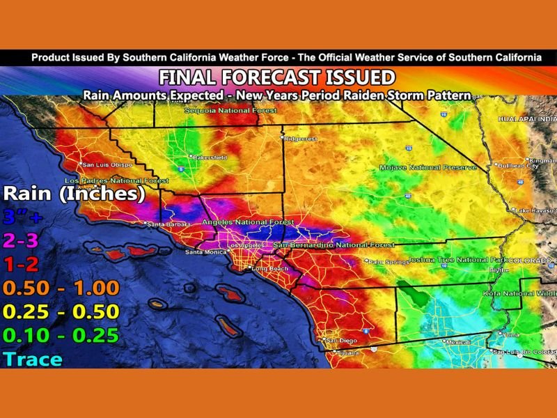
Storm to Bring Heavy Rain, Mountain Flooding, and Dangerous Winds
Forecasters with Southern California Weather Force say the system will begin affecting the region late Wednesday and intensify through the New Year period. Strong low-level flow combined with orographic lifting is expected to produce significant rainfall across metro areas, especially near foothill and mountain zones.
The rainfall forecast map shows several areas — including Los Angeles County, Orange County, Ventura County, Santa Barbara, San Diego, and the Inland Empire — positioned for 1 to 3+ inches of rain, with localized higher amounts possible in mountainous terrain. Flash flooding, debris flows, and rapid runoff are all concerns, particularly in burn scar regions and steep terrain where water can accumulate quickly.
Winds Could Topple Trees and Damage Property
Forecasters warn that strong southerly winds associated with the storm may cause tree damage and power outages. Residents are advised to avoid parking vehicles beneath large trees during the storm period, as gusts could topple branches or uproot weakened trees.
Wind impacts are expected across all major metro areas, with the highest low-level shear and upper-level wind divergence predicted for New Year’s Day, creating additional hazards.
Risk of Severe Thunderstorms and Possible Tornadoes
In addition to heavy rain and strong winds, the storm’s atmospheric dynamics may produce severe thunderstorms, bringing the possibility of hail, damaging gusts, and isolated tornado activity. Forecasters note that conditions will need to be monitored closely as the system approaches, with additional updates expected as more data becomes available.
Rare Category Six Rating Highlights Seriousness of the Event
Southern California Weather Force officials say the Category Six rating is not based on rainfall alone, but on the combined threat of wind damage, flooding, coastal impacts, and the severe weather potential. This classification is extremely rare and reflects the broad scope of hazards expected.
The Raiden Storm Pattern — a setup that produces sequential storms — means that another system may follow approximately one week later, prolonging the region’s unsettled weather.
Areas of Greatest Concern
Meteorologists are focusing closely on:
- Los Angeles County
- Orange County
- Ventura and Santa Barbara Counties
- San Diego County
- Inland Empire communities
- Mountain and foothill regions prone to runoff and debris flows
Residents in these zones should prepare for rapidly changing conditions, potential road closures, and hazardous driving during periods of heavy rain and flooding.
Preparing for the Holiday Storm
Officials advise residents to:
- Secure outdoor furniture and loose items
- Move vehicles away from large trees
- Avoid driving through flooded roadways
- Stay updated with evolving forecasts through trusted local outlets
As Southern California prepares for this rare New Year’s system, readers are encouraged to stay safe, monitor real-time updates, and share local storm impacts at SaludaStandard-Sentinel.com.