Southeast States, Especially Florida, Expected to Stay Mostly Dry Through December 2nd as La Niña Pattern Limits Rainfall
FLORIDA — Residents across the Southeast, and especially Florida, hoping for significant rainfall in the days ahead will likely be disappointed. New long-range precipitation guidance shows very limited rain through December 2, with most of the region staying under a persistent dry high-pressure influence.
The NOAA Blend of Models paints a clear picture: the Southeast is expected to see some of the lowest rainfall totals in the country as La Niña conditions continue to dominate the weather pattern.
Models Show Minimal Rainfall Across Florida and the Southeast
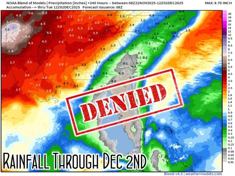
A detailed rainfall projection shared through Spaghetti Models shows that much of Florida, Georgia, Alabama, and the Carolinas will receive only 0.0 to 0.2 inches of rain over the next 10 days.
The map highlights a strong west-to-east gradient, with heavy rainfall in the Southern Plains and Lower Mississippi Valley, but almost nothing reaching the Florida Peninsula.
Meteorologists say this is a classic La Niña setup: drier-than-average conditions across the southern tier of the United States, especially as high pressure strengthens over the region.
Dry Pattern Expected to Persist Under La Niña Influence
The Southeast’s dry trend is tied to the ongoing La Niña pattern, which traditionally pushes storm systems farther north while leaving the southern states with:
- Weaker moisture flow
- More frequent high-pressure dominance
- Fewer Gulf or Atlantic storm tracks
- Below-normal precipitation
Experts say this pattern is expected to hold at least through the end of the Thanksgiving weekend and into the first days of December.
Rainfall Totals Highlight Major Regional Contrast
While Florida sees almost no precipitation, states to the west—including Texas, Oklahoma, Arkansas, and Louisiana—are forecast to receive 3 to 8 inches in some areas.
The map’s sharp color contrast shows:
- Deep red and orange shading over the Southern Plains, indicating high rainfall totals
- Light green to gray shading over Florida, indicating extremely low or near-zero rainfall
This pronounced difference underscores how sharply the storm track avoids the Southeast in La Niña setups.
What Southeast Residents Should Expect Through December 2
Forecasters say the region should expect:
- Dry days with little to no measurable rain
- Cool nights and mild afternoons under high pressure
- Increased fire-weather concerns in drier inland areas
- Watering needs for lawns and landscaping due to lack of natural moisture
- A higher likelihood that early-December cold fronts will pass through dry
Meteorologists note that while the pattern could shift later in December, the immediate outlook offers no significant rain relief for Florida or the Southeast.
If you live in the Southeast and want to share how the dry conditions are affecting your area, join the conversation at SaludaStandard-Sentinel.com.