Snow Begins Falling in Charlotte and Surrounding Areas as Winter System Moves Across the Carolinas
CHARLOTTE, N.C. — A light but steady wave of snow has moved into Charlotte and surrounding areas as a cold front sweeps across the Carolinas Monday evening, marking the first measurable snowfall of the season for many parts of North Carolina.
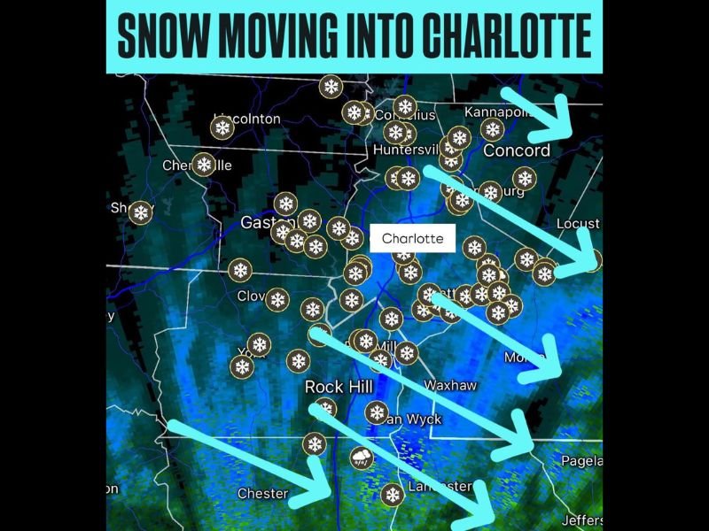
Meteorologist Chris Nunley confirmed the arrival of snow at 5:40 p.m. EST, sharing radar images showing snow bands stretching from Rock Hill northward through Gastonia, Huntersville, and into Concord.
Early Evening Flurries Across the Metro Area
According to Nunley’s latest update, snow began pushing into the Charlotte metro region from the southwest, creating slick road conditions and reducing visibility across parts of Mecklenburg, Gaston, and Union Counties.
Radar imagery shows widespread snow icons spreading northeast, indicating consistent light-to-moderate flurries. Residents from Rock Hill to Huntersville reported snow sticking to cars, lawns, and rooftops as temperatures hovered near the freezing mark.
Conditions Expected to Persist Overnight
Forecasters expect snowfall to continue into the late evening hours before tapering off overnight as the system moves east. The National Weather Service advises drivers to exercise caution on bridges and elevated surfaces where icy patches may quickly form.
While snow accumulation is expected to remain light — mainly a dusting to one inch in most areas — meteorologists warn that colder overnight lows could create hazardous travel conditions Tuesday morning.
Surrounding Areas Also Seeing Snow
Communities across Chester, Lancaster, and Clover in South Carolina also reported evening flurries as the system extended into the Piedmont region.
Further north, snow showers have been observed near Kannapolis, Cornelius, and Huntersville, where radar data suggests narrow but intense snow bands moving through.
First Taste of Winter for Charlotte Residents
The early-season snowfall comes amid a sharp cold front that has brought below-normal temperatures to much of the Southeast. For many in the Charlotte region, it marks the first true sign that winter weather has arrived.
Local residents have taken to social media sharing photos and videos of the snow, with several posting comments about the unexpectedly early flakes for mid-November.
Meteorologists say the brief snow event is part of a larger cold-air outbreak spreading across the eastern United States, with additional freeze warnings possible later this week.
Travel Caution and Safety Reminders
Officials urge residents to allow extra time for travel Monday night and early Tuesday, especially in elevated or shaded areas prone to freezing.
Drivers are advised to:
- Slow down and increase following distance.
- Avoid sudden braking on bridges or overpasses.
- Check local advisories before morning commutes.
More snow chances could return later in the week depending on storm development patterns over the southern Appalachians.
For continued updates on North Carolina’s winter weather and road conditions, visit SaludaStandard-Sentinel.com.