Severe Weather Outbreak Likely Wednesday Night Across Northwest Ohio and Southeast Michigan With Two Rounds of Storms and 1 to 2 Inch Rainfall Totals
TOLEDO, OH — A severe weather outbreak is becoming increasingly likely Wednesday night across northwest Ohio and southeast Michigan, with two distinct rounds of storm activity expected between 9 p.m. and 3 a.m., very heavy rainfall totals of 1 to 2 inches widespread across the region, and an unusually powerful low pressure system driving the setup — a storm more characteristic of November than June.
An Unusual Low Pressure for June
The storm system driving Wednesday night’s severe weather threat is described as quite powerful for a June event, with forecasters noting they would more typically expect to see a low pressure of this strength during November rather than summer. This characteristic means traditional summer instability and sizzling heat will play less of a role than usual, with the storm’s dynamics themselves providing the primary forcing mechanism for severe weather development.
Two Storm Rounds to Watch
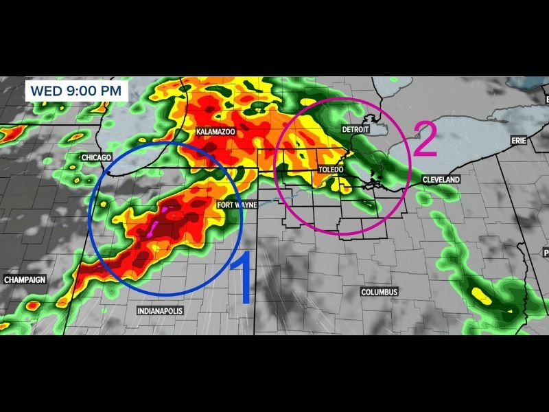
WTOL 11 Weather Impact hour-by-hour radar simulation valid Wednesday at 9:00 p.m. identifies two distinct areas of concern for the overnight event. Area 1, circled in blue on the radar, shows intense storm activity centered near Chicago, Fort Wayne, and Indianapolis — with deep red and magenta cores indicating the most dangerous portion of the first round as it pushes through the Indiana and Illinois corridor.
Area 2, circled in pink, depicts a separate storm cluster near Toledo and Detroit, positioned between the Great Lakes and extending toward Cleveland. Forecasters indicate the second round carries the higher severe weather threat of the two, making the late-night and early-morning hours particularly critical for northwest Ohio and southeast Michigan residents.
Rainfall and Flood Concern
Very heavy rainfall is expected with this system, with widespread 1 to 2 inch totals likely across most of northwest Ohio and southeast Michigan. The combination of back-to-back storm rounds producing heavy rainfall over the same area could lead to localized flash flooding concerns, particularly in urban areas and poor drainage zones through the overnight hours.
What Residents Should Do
Residents across northwest Ohio, southeast Michigan, and the Toledo and Detroit metro corridors should keep weather alert systems active through the overnight hours and have a shelter plan ready before going to sleep Wednesday evening.
For continuing coverage of Ohio and Michigan severe weather across the United States, visit SaludaStandard-Sentinel.com.