Severe Thunderstorm Warning Issued for Southwestern Oklahoma as Storms Intensify Near Duncan and Comanche
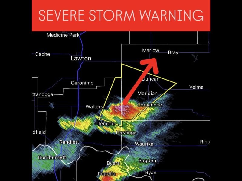
OKLAHOMA — The National Weather Service has issued a Severe Thunderstorm Warning for southwestern Oklahoma, with strong storms moving through Duncan, Comanche, and Empire City this evening. The alert is in effect until 6:45 p.m. CST as radar indicates heavy rainfall, intense lightning, and strong wind gusts.
Storms Developing Along the Red River Corridor
Weather radar imagery shows a line of severe storms stretching from Temple to Hastings, pushing northeast toward Duncan and Marlow. These storms are producing heavy rain, hail, and wind gusts exceeding 60 mph, capable of damaging roofs, power lines, and small structures.
Residents in the warning area should seek shelter immediately, especially those living in mobile homes or structures with limited protection.
Communities Under the Warning Zone
The primary cities included in the warning area are:
- Duncan
- Comanche
- Empire City
- Meridian
- Temple
- Hastings
Additional nearby communities such as Marlow, Geronimo, and Walters may also experience hazardous weather conditions as the storm system advances northward.
Potential Hazards and Safety Precautions
According to meteorologists, the storm cell has developed a well-defined core, with possible small hail and rapid intensification. Residents are advised to remain indoors and away from windows during the storm.
Safety officials recommend:
- Moving vehicles to covered areas to avoid hail damage.
- Staying clear of flooded roadways.
- Monitoring NOAA Weather Radio or trusted local news outlets for updates.
More Storms Possible Through the Evening
This severe thunderstorm is part of a broader system affecting southern Oklahoma and north Texas, with additional rounds of rain and isolated storms expected later tonight. Forecasters warn that some storms could become severe again overnight, especially in areas south of Lawton.
The National Weather Service continues to track storm movement in real-time, urging residents to stay alert and ready to act if conditions worsen or new warnings are issued.
For updates on severe weather alerts and safety information across the Southeast and Midwest, visit SaludaStandard-Sentinel.com.