Severe Storm Risk for Texas and Oklahoma as New System Moves Across Southern Plains
DALLAS, Texas — The Southern Plains are bracing for another round of severe weather today, as a storm system pushes across Texas and Oklahoma, creating conditions favorable for hail, damaging winds, and a possible brief tornado.
Meteorologists say while overall instability remains low, the system’s high wind shear could lead to a few strong storms this afternoon and evening, especially if any cells become surface-based.
Storm Setup and Main Threats
According to forecasters, the storm system approaching from the west will bring showers and thunderstorms through much of the afternoon.
The most concerning threat will be large hail, with some stones potentially exceeding 1 inch in diameter.
“Even with limited instability, strong upper-level winds will make the environment capable of producing rotating storms,” forecasters explained. “That raises the chance of brief, weak spin-ups or isolated severe storms.”
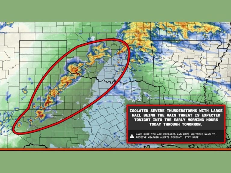
The Storm Prediction Center (SPC) highlights a “best chance” zone for tornado and hail potential across Midland, Abilene, and Lubbock, where storms will likely develop first before tracking east into Fort Worth and Brownwood later in the evening.
Areas Under Highest Risk
- Greatest hail and tornado potential: Midland, Abilene, Lubbock
- Secondary severe risk zone: Fort Worth, Cleburne, Brownwood, Waco
- Hazards: Large hail (primary), isolated damaging wind gusts, brief tornado possible
In the yellow-shaded region (as shown on the severe weather outlook map), forecasters say storms could strengthen rapidly once they tap into near-surface moisture and shear.

Timing and Progression
Thunderstorms are expected to develop during the early afternoon hours, intensifying into early evening.
Storms will move eastward toward central Texas after sunset, weakening as they encounter drier air.
Residents should prepare for sudden hail-producing storms and monitor local radar updates throughout the evening.
Forecaster Notes
Although the tornado potential remains low, forecasters warn that any isolated storm could briefly rotate given the strong wind dynamics.
This setup is typical of early winter transition systems, which often feature low instability but high shear — a combination capable of producing sporadic severe storms.
“Hail remains the highest concern today,” meteorologists noted. “Even non-tornadic storms could drop sizable hail that may damage vehicles and roofs.”
Safety Tips for Today’s Severe Weather
- Move vehicles to covered areas to protect from hail damage.
- Stay indoors and away from windows during thunderstorms.
- Have multiple ways to receive severe weather alerts, especially for tornado warnings.
- If driving, avoid flooded or hail-covered roads and pull over safely if visibility drops.
The system is expected to move out of the region overnight, with calmer conditions returning by Tuesday morning. However, another storm wave is possible later this week as temperatures fluctuate across the Plains.