Persistent Gulf Rain Band Targets Florida, While Louisiana, Mississippi, and Alabama Remain Mostly Dry in Latest Radar Sweep
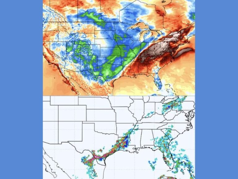
GULF COAST — A long, organized band of rain stretching across the Gulf of Mexico is delivering steady rainfall to Florida, while nearby states — Louisiana, Mississippi, and Alabama — remain largely untouched by the moisture. Radar imagery late Saturday shows a robust corridor of showers parked across the eastern Gulf and Florida peninsula, leaving the western Gulf Coast comparatively dry.
Radar Shows Florida Absorbing Nearly All the Gulf Moisture
The latest radar scan displays a pronounced eastward tilt to the rainfall, with the heaviest concentrations focused over North and Central Florida, including areas near Jacksonville and Gainesville. Bands continue feeding in from the Gulf, creating continuous light to moderate rain along the state’s northern tier.
Meanwhile, states immediately west — Louisiana and Mississippi — show minimal precipitation, with only a few scattered returns near the coastline. Portions of Alabama display light radar echoes but remain mostly on the edge of the main moisture plume.
Forecasters note that this split is the result of a sharply angled moisture feed, causing the showers to sweep eastward instead of distributing across the broader Gulf Coast.
Louisiana, Mississippi, and Alabama See a Rare Break in Wet Conditions
Despite recent active weather patterns, Louisiana, Mississippi, and coastal Alabama are enjoying a rare window of dry, stable conditions. Communities from New Orleans to Biloxi and Mobile remain largely rain-free as the system shifts its focus toward the Florida peninsula.
This dry pocket is expected to hold through the short term, giving residents a break while Florida continues dealing with repeated rainfall bands pushing ashore.
Meteorologists emphasize that sometimes the Gulf’s steering currents align in such a way that one state absorbs the bulk of the rainfall, and today’s setup shows Florida taking the full impact.
Florida Residents Should Expect Continued Onshore Showers
With the moisture channel positioned directly over the peninsula, Florida residents should anticipate ongoing showers, especially across northern and northeastern regions. Light rain may persist through the evening as new pockets of Gulf moisture rotate inland.
Although rainfall totals are not expected to be severe, the steady nature of the band may lead to wet roads, reduced visibility, and minor travel delays.
The Gulf Coast weather pattern remains fluid, but for now, the divide is clear: Florida gets the rain, and the western Gulf states get the break.
Have you noticed the sharp east–west rainfall split where you live? Share your updates and follow the latest regional coverage at SaludaStandard-Sentinel.com.