Penrose Colorado 24 Fire Forces Evacuations Near County Road F45 and Highway 115 as Blaze Surpasses 1,000 Acres
COLORADO — Evacuations are actively underway in the Penrose area as the rapidly growing 24 Fire has prompted emergency officials to issue urgent orders for residents near key roadways.
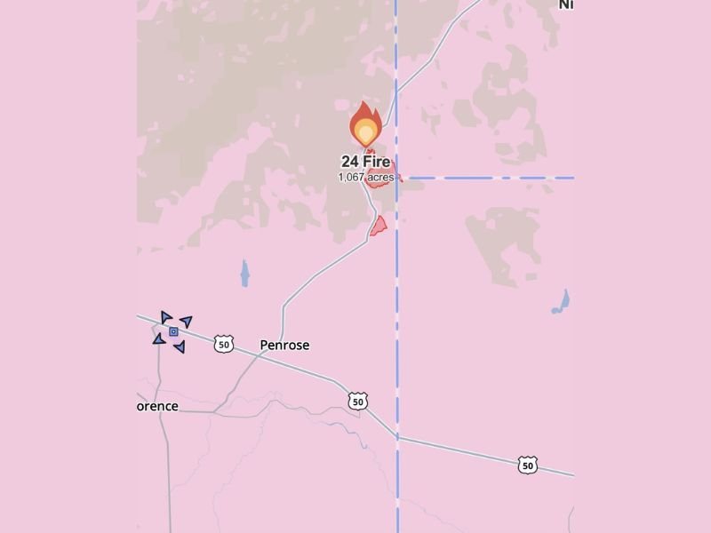
Authorities confirmed that a 2-mile evacuation order has been issued around County Road F45 and State Highway 115, as the wildfire continues to expand and threaten nearby communities.
Evacuation Orders Issued as Fire Expands Rapidly
The 24 Fire has already burned over 1,000 acres, with officials estimating the fire size at approximately 1,067 acres as it continues to spread through dry terrain.
Emergency alerts sent through Everbridge systems have instructed residents within the immediate impact zone to evacuate without delay. The evacuation area centers around critical routes near County Road F45 and Highway 115, where fire activity remains most intense.
Officials warn that conditions can change quickly, and residents in the evacuation zone should leave immediately to ensure their safety.
Pre-Evacuation Notice Extends Beyond Immediate Fire Zone
In addition to mandatory evacuations, a 3-mile pre-evacuation notice has been issued for surrounding areas in Penrose. This alert serves as a warning for residents to prepare for possible evacuation if the fire continues to grow or shift direction.
Pre-evacuation zones are designed to give families time to gather essentials, secure pets and livestock, and plan exit routes in advance. Authorities emphasize that those in these areas should remain alert and ready to leave at a moment’s notice.
Fire behavior can be unpredictable, especially under changing wind conditions, increasing the urgency for nearby residents to stay informed.
Shelter and Emergency Support Available for Residents
Residents, along with their pets and livestock, have been directed to evacuate to Pathfinder Park, which is currently serving as a designated safe location.
Emergency officials have also provided a public contact number for evacuation-related questions and assistance. Residents needing additional guidance or support are encouraged to call 719-276-7421 for updated instructions.
Local agencies continue to coordinate efforts to ensure safe evacuation and provide necessary resources for displaced families.
Fire Location and Ongoing Risk in Penrose Area
Mapping data shows the fire burning north of Penrose, with flames advancing through rural areas and approaching key roadways. The surrounding region remains under heightened alert due to the fire’s size and ongoing activity.
With over 1,000 acres already affected, containment efforts are ongoing, though no timeline has been given for when the fire may be brought under control.
Officials continue to monitor weather conditions and fire spread closely, urging residents to stay updated through official alerts and emergency communication systems.
If you are in the Penrose area or nearby communities, share your experience or updates with us as this situation develops. Stay connected with SaludaStandard-Sentinel.com for continuous coverage and critical safety information.