Pennsylvania Snow Friday Could Include Squalls Before Arctic Blast Slams State With -30 Wind Chills and 50 MPH Gusts
PENNSYLVANIA — A fast-moving clipper is expected to spread snow across the state Friday into Friday afternoon, but the bigger story may come right behind it: an arctic blast that could drive temperatures into the single digits and push wind chills to -20 to -30 degrees by Saturday, according to the latest forecast update.
Snow Friday With a Risk of Quick-Hitting Squalls
The clipper system is forecast to bring periods of snow from Friday morning through the afternoon statewide. While totals are expected to be lower than the late-January winter storm, the update warns that embedded snow squalls and heavier bursts could create sudden, slick travel conditions—especially during the Friday evening and overnight window.
Those quick-hitting squalls can drop visibility in minutes and rapidly coat untreated roads, which is why the Friday night period is being flagged as the most likely time for travel headaches.
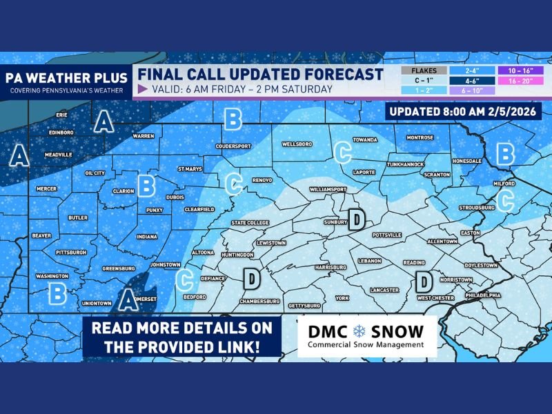
Updated Snow Map Shows Higher Totals West and North
A “final call” snow map valid from 6 a.m. Friday to 2 p.m. Saturday shows a clear gradient across Pennsylvania:
- Northwest and higher terrain in the west appear favored for the highest totals, with several pockets in the 4–6 inch range.
- Much of western and north-central Pennsylvania sits in a 2–4 inch zone.
- A broad stripe across parts of the north and northeast trends closer to 1–2 inches.
- Central and southeastern Pennsylvania, including the Harrisburg–Lancaster–Philadelphia corridor, is shown in the lightest category—generally a coating to under 1 inch.
Saturday Brings the Coldest Air of the Season So Far
After the snow moves through, the forecast turns sharply colder. The update notes afternoon temperatures on Saturday may struggle to rise out of the single digits, and with wind gusts around 40–50 mph, wind chills could plunge to -20 to -30 degrees in the coldest periods.
That combination can become dangerous quickly for anyone spending time outdoors, and it also raises the risk of problems like frozen pipes and stress on power lines, with power outages mentioned as a legitimate concern during the worst of the cold and wind.
What to Watch and When Impacts Are Most Likely
The main timing takeaway is simple: snow and squall risk Friday, then dangerous cold and strong wind Saturday. Even if your snow total is modest, the Friday-night travel window and the Saturday wind chill threat could still produce real impacts.
What are you seeing where you live in Pennsylvania—steady snow, quick bursts, or mostly wind and cold? Share your local conditions and stay with SaludaStandard-Sentinel.com for continuing updates.