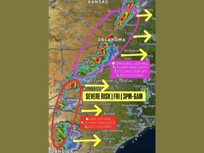
Oklahoma Texas Kansas Severe Weather Friday Threat From 3 PM to Overnight With Hail Winds and Isolated Tornado Risk
OKLAHOMA, TEXAS, KANSAS — A widespread severe weather setup is expected to unfold Friday afternoon through the overnight hours, bringing the potential for large hail, damaging winds, and isolated tornadoes across multiple states.
Storms are forecast to begin developing between 3 PM and 5 PM across western Oklahoma and western Texas before expanding into a larger system moving east and southeast through the evening and night.
Storm Development Expected Along Dryline and Cold Front
The setup shows storms initially forming along a dryline and advancing cold front, creating an environment supportive of severe thunderstorm development.
These early storms are expected to remain somewhat isolated at first, allowing them to strengthen quickly and produce more intense impacts before merging into a broader system. Areas including western Oklahoma, Wichita Falls, and portions of west Texas are likely to see the first development.
Large Hail and Strong Winds Possible in Early Storms
The initial discrete storms will carry the highest severe potential, including hail that could reach lime to tennis ball size.
Wind gusts may exceed 70 mph in stronger cells, and the atmospheric setup also supports the possibility of a few isolated spin-up tornadoes during this phase. This early window will be critical as storms remain more organized and capable of producing significant severe weather.
Storms Merge Into Squall Line Overnight
As the evening progresses, storms are expected to grow in coverage and merge into a squall line stretching from Kansas through Oklahoma into Texas. Once this transition occurs, the primary threat will shift slightly.
Hail sizes may decrease to around half-dollar to golf ball size, but the risk of damaging straight-line winds increases significantly along the line. Embedded spin-up tornadoes remain possible within the squall line, though they are expected to be brief and less organized.
Severe Threat Extends Across Multiple States
The corridor of concern extends from parts of Kansas through central and eastern Oklahoma and into north and central Texas.
Cities and regions including Enid, Tulsa, Norman, Wichita Falls, Dallas-Fort Worth outskirts, and areas stretching toward Arkansas could all see impacts as storms track eastward. The system is expected to continue overnight, gradually weakening as it pushes farther east.
Residents Urged to Prepare Ahead of Friday’s Storms
With multiple hazards possible, residents across Oklahoma, Texas, and Kansas are encouraged to stay weather-aware and have multiple ways to receive warnings.
The combination of large hail, strong winds, and isolated tornado potential makes this a situation that could evolve quickly, especially during the late afternoon and evening hours.
If you’re in the path of these storms or expecting impacts Friday, share your updates and stay informed with the latest coverage on SaludaStandard-Sentinel.com.