Oklahoma City and Moore Oklahoma Under Tornado Warning as Radar Indicates Circulation With Damaging Winds and Hail Risk
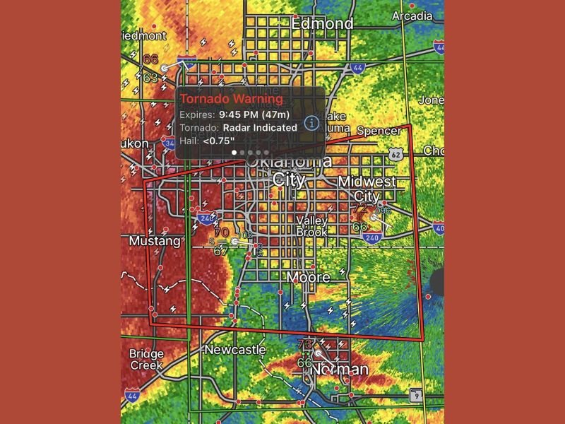
OKLAHOMA CITY, OKLAHOMA — A tornado warning was issued Friday evening for Oklahoma City and Moore as a powerful storm system showed radar-indicated rotation, raising concerns for a possible tornado along with damaging winds and hail.
The warning, set to expire at 9:45 PM, covered a densely populated portion of central Oklahoma, placing thousands of residents in the direct path of a potentially dangerous storm.
Radar Indicates Rotation Moving Through Metro Area
Weather radar imagery revealed a strong storm cell moving across the Oklahoma City metro, with clear signs of rotation embedded within a larger area of heavy rain and thunderstorms. The storm appeared to track eastward, impacting areas from Mustang through central Oklahoma City and toward Moore.
The presence of rotation significantly increased the risk level, prompting urgent warnings for residents to take immediate precautions.
Damaging Winds and Hail Add to the Threat
In addition to the tornado concern, the storm system was capable of producing damaging wind gusts and hail. Radar estimates suggested hail sizes approaching three-quarters of an inch, along with strong wind signatures that could lead to localized damage.
Areas including Midwest City, Valley Brook, and Norman were also within or near the storm’s broader impact zone as it continued to move through central Oklahoma.
High Lightning Activity and Heavy Rain Reduce Visibility
The storm brought intense lightning activity across the region, along with heavy rainfall that could quickly reduce visibility on roadways. Major highways, including Interstate 35 and Interstate 44, were likely impacted during peak storm intensity.
Drivers in and around Oklahoma City were urged to avoid travel during the most intense periods of the storm due to rapidly deteriorating conditions.
Residents Urged to Take Immediate Shelter
With a tornado possible and severe storm conditions ongoing, residents were advised to move to interior rooms on the lowest floor of their homes and stay away from windows. The warning emphasized the importance of acting quickly as storms moved through populated areas.
Even without a confirmed tornado touchdown, the radar-indicated rotation warranted serious caution across all impacted communities.
Storm Continues East With Ongoing Risk
As the storm progressed eastward beyond Oklahoma City and Moore, the threat was expected to shift toward surrounding areas. However, conditions could remain dangerous for a period even after the storm passes, particularly with debris, standing water, and potential power outages.
Residents are encouraged to continue monitoring updates and remain alert as conditions evolve throughout the evening. If severe weather impacted your area, share your experience with us at SaludaStandard-Sentinel.com and help keep others informed during rapidly changing conditions.