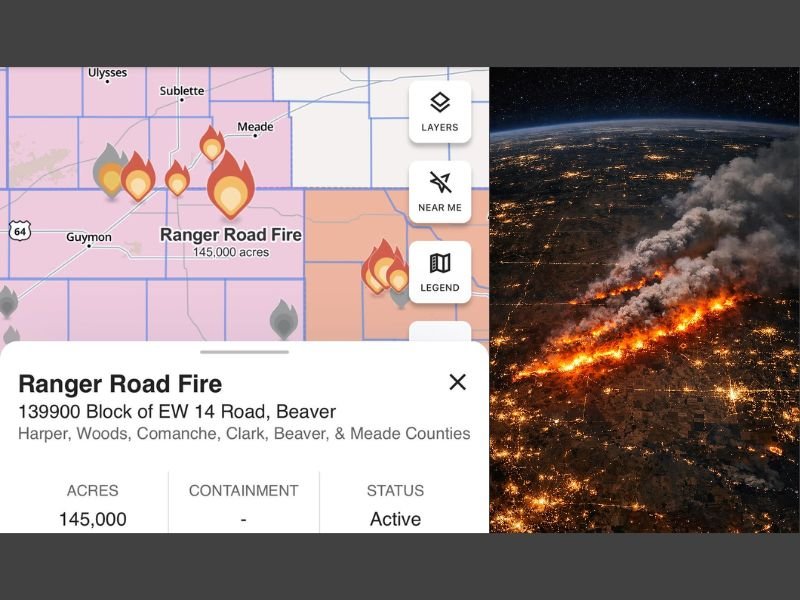
Oklahoma and Kansas Ranger Road Fire Explodes to 145,000 Acres, Earning “Megafire” Label as Crews Face Active Spread
UNITED STATES — A fast-growing wildfire straddling the Oklahoma Panhandle and southern Kansas has surged to an estimated 145,000 acres, with the incident now being described as a classified “megafire” as flames expand across multiple counties and the fire remains listed as active.
What The Latest Data Shows On The Ranger Road Fire
The incident is being tracked as the Ranger Road Fire, with a listed origin area near the 139900 block of EW 14 Road in Beaver. The acreage estimate shown in the data totals 145,000 acres, and the fire’s status is marked Active, signaling that spread and smoke impacts may still be ongoing for nearby communities and travel corridors.
The containment field is shown as a dash, indicating containment has not been provided in the snapshot shown, or remains unconfirmed in the information available from the shared report.
Counties Impacted Across Oklahoma And Kansas
The fire footprint and response area referenced in the data spans a broad multi-county region, including:
- Harper County
- Woods County
- Comanche County
- Clark County
- Beaver County
- Meade County
With multiple counties listed, officials typically warn that conditions can vary dramatically from one area to the next—especially as wind shifts push fire lines and smoke plumes in new directions.
Why “Megafire” Designation Matters
A wildfire reaching this size often signals a situation where suppression becomes more complex, not only because of the sheer acreage, but also because of how quickly fire behavior can change when winds increase, humidity drops, or fuels stay critically dry. Even if flames are not immediately threatening a specific town, smoke, reduced visibility, and rapid flare-ups can create new hazards with little notice.
What Residents Should Do Next
For people in or near the listed counties, the most important steps are practical and immediate:
- Monitor local emergency management updates and evacuation information
- Avoid travel through heavy smoke or near active fire zones
- Keep phones charged and have go-bags ready if warnings are issued
- If you have respiratory issues, reduce outdoor exposure when smoke thickens
As the Ranger Road Fire remains active, updated acreage and containment figures may change quickly as mapping improves and crews assess the fire edge.
If you’re seeing smoke or road closures in your area, share what you’re noticing and keep following SaludaStandard-Sentinel.com for additional updates.