Ohio River Valley Braces for Feb. 19 Severe Weather Threat as “All Hazards” Zone Highlights Wind, Hail, and Possible Tornado Setup
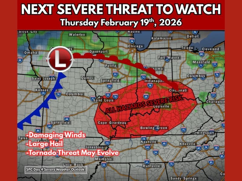
OHIO RIVER VALLEY — A new severe weather setup is taking shape for Thursday, February 19, 2026, with an “all hazards” risk area highlighted across parts of the Ohio River Valley as forecasters monitor a system capable of producing damaging winds, large hail, and a tornado threat that could evolve.
What the “All Hazards” Severe Risk Area Covers
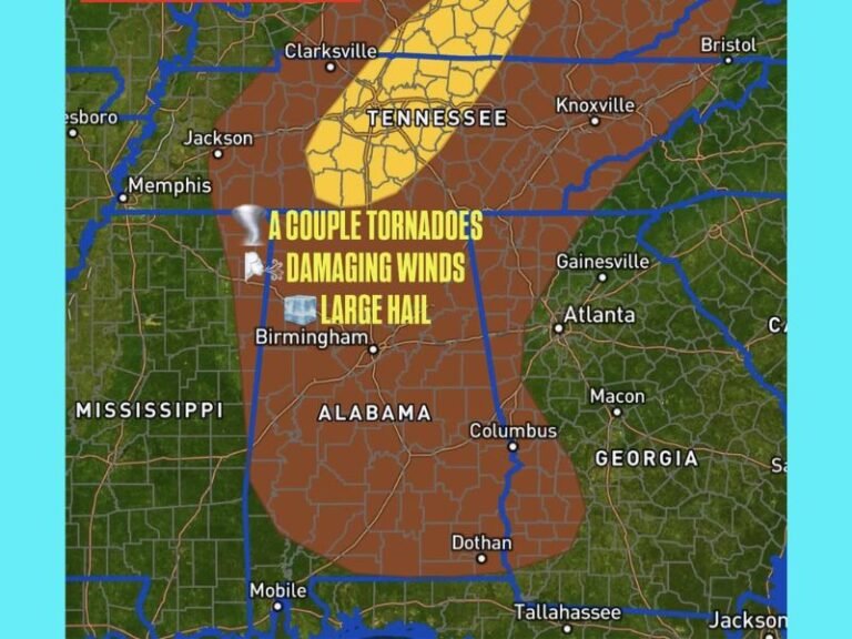
The highlighted risk zone stretches across a large section of the region and includes areas around Louisville and Cincinnati, with the broader shaded region also reaching into parts of southern Indiana, central Kentucky, and portions of southern Illinois and southeast Missouri.
The setup shown features a low pressure system to the west with a warm front lifting northeast and a cold front advancing behind it—an arrangement that often sets the stage for storms to develop along boundaries and intensify as they move east.
Why Forecasters Are Watching the Warm Sector Closely
One of the biggest details in this outlook is the focus on the system’s warm sector, where warmer, more humid air can fuel stronger storms. Some forecast models are also hinting at the potential for warm-front storms, which can sometimes increase tornado potential depending on how much instability and wind shear overlap.
At this stage, the tornado threat is being flagged as something that “may evolve,” meaning it could increase if the atmosphere becomes more supportive as the event gets closer.
Main Hazards: Damaging Winds, Large Hail, and a Tornado Risk That Could Change
The forecast graphic lists damaging winds and large hail as key hazards, with the tornado threat noted as a possibility that could develop. In many Ohio Valley severe weather setups, the main line of storms can bring strong wind gusts, while discrete storms ahead of the line—if they form—can raise the hail and tornado risk.
That’s why timing and storm mode will matter, and why the forecast will likely get sharper as Thursday approaches.
What Residents Should Do Before Thursday Arrives
With a multi-hazard risk being highlighted several days out, this is the time to make sure alerts are enabled on phones, weather radios are ready, and families know where to go if warnings are issued—especially overnight or during the evening commute when storms can be harder to track.
If you live in the Ohio River Valley and want to share what conditions look like as the system approaches, join the conversation at SaludaStandard-Sentinel.com and tell us what you’re seeing in your area.