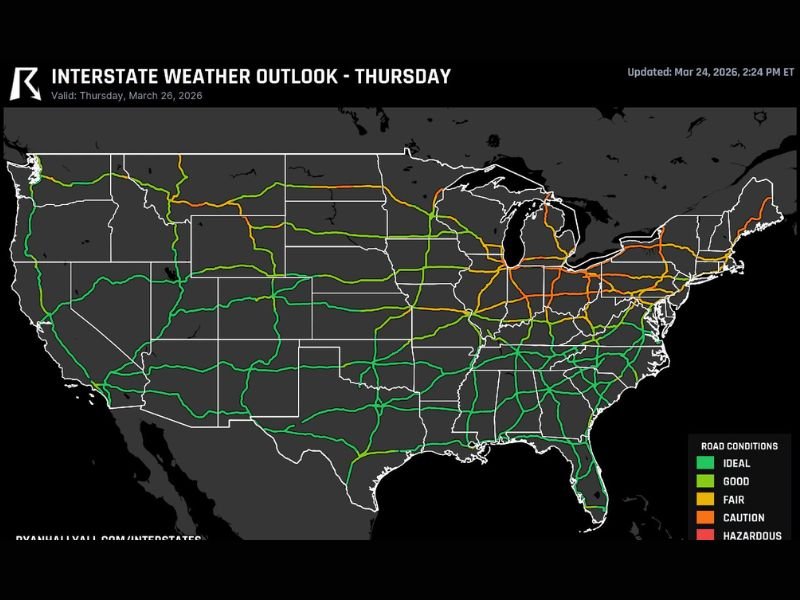
Ohio, Indiana, Illinois, New York and Northern New England Face Heavy Rain, Gusty Winds and Winter Mix Disrupting I-80 and I-90 Travel Thursday
OHIO VALLEY — A large stretch of unsettled weather is expected to impact travel Thursday across Ohio, Indiana, Illinois, and into New York and northern New England. Storms moving along major interstate corridors like I-80 and I-90 will bring heavy rain, gusty winds, and changing road conditions throughout the day.
The system is forecast to move steadily east, starting in the Midwest before reaching the Northeast by evening, creating a long corridor of travel disruptions across multiple states.
Storms Target Ohio, Indiana and Illinois Interstate Corridors
The most immediate concern begins across Ohio, Indiana, and Illinois, where storms are expected to develop along major routes including I-80 and I-90. These storms will bring periods of heavy rainfall combined with gusty winds, making driving conditions more dangerous than usual.
Drivers may encounter reduced visibility during downpours, along with slick road surfaces that increase the risk of accidents. High-traffic routes connecting cities like Chicago, Indianapolis, and Cleveland could see slow-moving traffic and delays as conditions worsen through the day.
Evening Rain Intensifies Across New York
As the storm system progresses eastward, New York—especially western portions of the state—will face a stronger round of rainfall later in the day. This evening surge is expected to bring steady and sometimes heavy rain, impacting travel during peak evening hours.
Roadways feeding into cities such as Buffalo and Rochester may become increasingly hazardous, with water buildup and slower traffic speeds becoming common. The timing of this rain could make evening commutes particularly challenging for drivers across the region.
Northern New England Braces for Winter Mix During Morning Commute
Unlike the rain-dominated pattern elsewhere, northern New England—including Vermont, New Hampshire, and Maine—will deal with a winter mix early in the day. This mix of snow, sleet, or freezing rain could create icy conditions, especially during the morning commute.
Bridges, overpasses, and higher elevation roads will be the most vulnerable to icing. Even a brief period of freezing precipitation can lead to dangerous travel conditions, catching drivers off guard and increasing the likelihood of accidents or delays.
Southeast Remains Calm While Northern States Face Disruptions
While much of the country deals with this storm system, the Southeast is expected to remain largely unaffected. Interstate routes across southern states are forecast to see stable and smooth travel conditions, providing a clear contrast to the active weather farther north.
This divide highlights how concentrated the impacts will be across the Ohio Valley and Northeast, with minimal disruption expected outside those regions.
Travel Conditions Expected to Change Rapidly Throughout the Day
Timing will play a key role in how this system affects travel. Conditions may start relatively manageable in parts of the Midwest before intensifying as storms move eastward. By the evening, areas in New York and beyond could see the most persistent rainfall.
Drivers planning to travel along I-80, I-90, or nearby routes should be prepared for changing conditions, allow extra time, and stay alert for sudden weather shifts. Even without severe storms, the combination of rain, wind, and winter mix is enough to significantly impact road safety.
If you are traveling through any of these affected states, share what you’re seeing on the roads and help others stay informed by visiting SaludaStandard-Sentinel.com.