Ohio Enters Its First Meaningful Winter Thaw in Weeks as Temperatures Trend Above Normal Into Late February
OHIO — After nearly a month of persistent cold and snow-covered ground, forecast data now indicate that Ohio is finally entering its first true winter thaw, with temperatures trending above seasonal averages through the second half of February. While winter is not over, the upcoming pattern marks a clear shift away from prolonged cold.
Forecast Pattern Signals a Shift Away From Deep Winter Cold
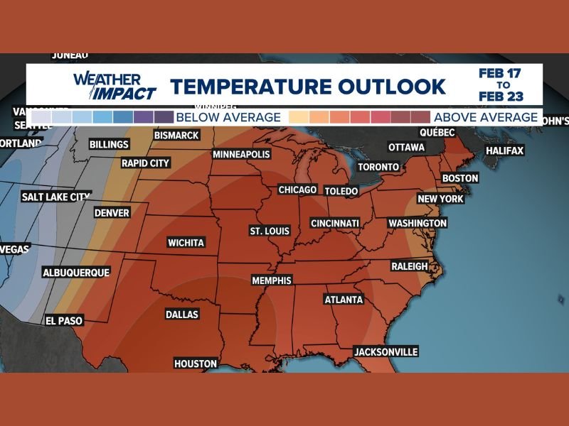
Temperature outlooks covering February 17 through February 23 show Ohio falling within a broad zone of above-average temperatures across much of the eastern United States. This represents a noticeable change from recent weeks, when cold air repeatedly reinforced snowpack and limited melting.
Meteorologists note that while short-term fluctuations are still possible, the overall pattern favors moderation rather than a return to severe cold.
Snow on the Ground Expected to Gradually Melt Over the Next 7–10 Days
As daytime highs climb, snow currently on the ground across much of Ohio is expected to melt over the next 7 to 10 days. The thaw will not be instantaneous, and colder nights may slow progress at times, but the overall trend supports shrinking snow cover rather than renewed accumulation.
This gradual melt is typical for late winter and is not expected to cause major flooding issues, as temperatures are rising steadily rather than abruptly.
Lake Erie Will Keep Northern Ohio Cooler Than Inland Areas
Communities near Lake Erie may notice a slower warm-up compared to inland locations. Cold lake influence often limits temperature increases near the shoreline, making it harder for highs to climb much beyond the 40s, even as other parts of the state warm more efficiently.
As a result, snow may linger longer in northern counties than in central or southern Ohio.
Inland Areas Could Reach the 50s Later Next Week
Away from Lake Erie, forecast guidance suggests that high temperatures above 50 degrees are possible next week, especially across central and southern Ohio. If realized, this would mark the warmest stretch many areas have experienced since early winter.
This warming will play a key role in accelerating snowmelt and restoring more seasonable ground conditions.
No Strong Signals for Major Storms or Renewed Arctic Outbreaks
Despite online speculation, current data do not support a major winter storm or significant cold outbreak during this period. While weather patterns can always evolve, the dominant signal remains one of milder conditions rather than renewed winter extremes.
Ohio residents can expect winter to slowly loosen its grip as February moves toward its final stretch.
For continued fact-based regional weather updates, visit SaludaStandard-Sentinel.com.