North Carolina Under Statewide High Fire Danger Alert Saturday as Strong Winds and Critically Low Humidity Raise Risk of Rapid Wildfire Spread
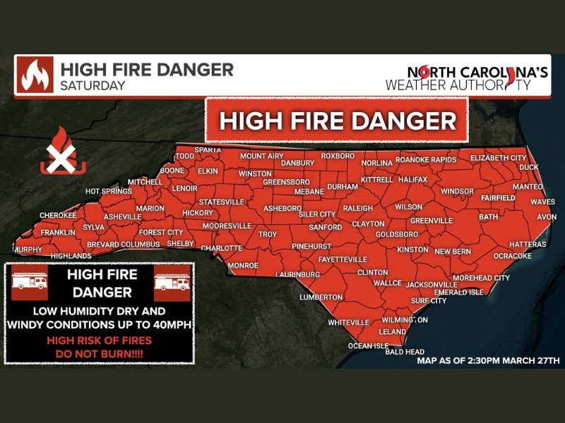
NORTH CAROLINA — A statewide high fire danger alert has been issued for Saturday as a combination of strong winds, very dry air, and low humidity levels creates a dangerous setup for wildfire ignition and rapid spread.
Officials warn that Red Flag conditions are either already in place in parts of the state or expected to develop, with the entire region facing elevated fire risk throughout the day.
Critical Fire Weather Conditions Expected Across Entire State
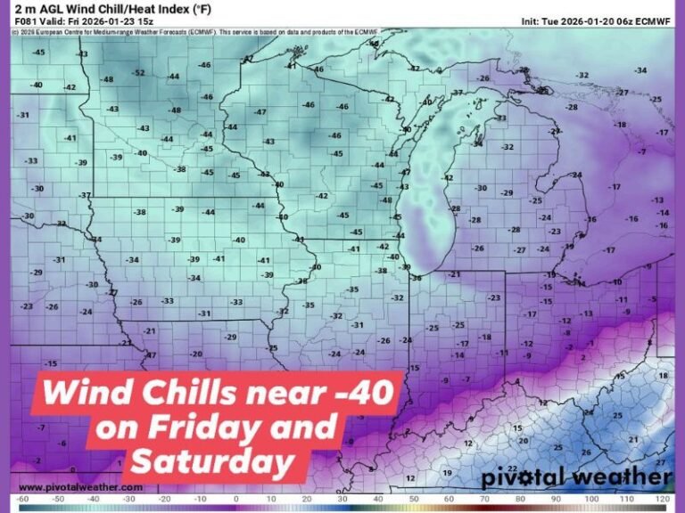
Meteorologists say the incoming cold front will usher in an exceptionally dry air mass across North Carolina, dropping relative humidity levels into the 10 to 20 percent range.
At the same time, northeast winds are expected to increase to 10 to 25 mph, with gusts reaching up to 30 to 40 mph in some areas. This combination of dry air and strong winds significantly increases the potential for fires to start and spread quickly. The alert covers both urban and rural areas, meaning fire danger is not limited to any single region within the state.
Red Flag Warnings Signal Highest Level of Fire Risk
A Red Flag Warning indicates that critical fire weather conditions are either occurring or will develop shortly. These warnings are issued when weather factors align to create an environment where fires can ignite easily and grow rapidly.
The current setup meets those criteria, with dry vegetation, gusty winds, and low humidity combining to create extreme fire behavior potential. Officials emphasize that even a small spark could lead to a fast-moving wildfire under these conditions.
Outdoor Burning Strongly Discouraged
Authorities are urging residents to avoid all outdoor burning activities during this high-risk period. This includes burning yard debris, brush piles, or any materials that could produce embers.
Even controlled burns can quickly become uncontrollable in this environment, especially when winds are capable of carrying embers over long distances. Residents are also advised to use caution with grills, equipment, and anything that could generate sparks.
Why Winds and Dry Air Make Fires Spread Faster
Strong winds act as a driving force for fire spread, pushing flames forward and allowing them to cover ground quickly. Meanwhile, low humidity dries out vegetation, turning grass, leaves, and debris into highly flammable fuel.
When these two factors combine, fires can intensify rapidly and become difficult to contain. This is why Red Flag conditions are treated with heightened concern by emergency management officials. The presence of a cold front adds to the instability, enhancing wind speeds and further drying out the air.
Residents Urged to Stay Alert and Prepared
Emergency officials across North Carolina are closely monitoring conditions and urging the public to remain vigilant. Staying informed about local restrictions and fire weather updates is critical during this period.
Residents should also be prepared to act quickly if a fire develops nearby, as conditions may allow flames to spread faster than usual.
The risk is expected to remain elevated through Saturday, particularly during peak daytime hours when winds and dryness are at their highest. Have you noticed dry conditions or fire concerns in your area recently? Share your observations and stay updated with the latest alerts at SaludaStandard-Sentinel.com.