North Carolina Braces for Quick-Hitting Line of Showers and Thunderstorms Friday Afternoon as Mild 70s Warmth Sweeps the State
NORTH CAROLINA — Friday will start mild and springlike across the state, with highs climbing into the 70s for many communities, but a quick-hitting band of showers — and possibly a rumble of thunder — is expected to sweep from west to east by mid-afternoon.
Forecasters say the system will not linger long, but residents shouldn’t be surprised by a sudden burst of rain and brief thunder as it passes.
Warm and Mild Before the Rain Arrives
Much of North Carolina will enjoy a noticeable warmup Friday, with temperatures reaching the low to mid-70s across central and eastern portions of the state.
The mild air will create a springlike feel through the late morning and early afternoon before the next weather feature moves in from the west.
Showers Enter Western North Carolina Around Midday
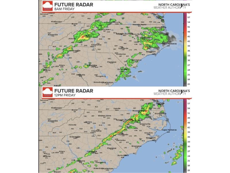
Future radar projections show a narrow band of showers developing across western North Carolina around midday.
By approximately 12 p.m., rain is expected to be pushing through areas near:
- Asheville
- Hickory
- Charlotte
The band will continue progressing eastward through the afternoon hours.
Storms Slide Through the Triangle and Eastern Counties
By mid-afternoon — around 3 p.m. — the line is forecast to stretch across central North Carolina, impacting communities including:
- Raleigh
- Durham
- Rocky Mount
- Greenville
While the system is expected to remain relatively narrow and fast-moving, embedded thunderstorms are possible within the band. Some locations could hear brief thunder as the showers move through.
Clearing Conditions by Late Afternoon
By approximately 5 p.m., the rain band is projected to move off the North Carolina coast, leaving behind clearing skies across most inland areas.
The quick-moving nature of the system means rainfall totals should remain limited, and the window for storms in any one location will likely be brief.
What Residents Should Expect
Forecasters emphasize:
- The system will move quickly from west to east
- Rain may fall in short, moderate bursts
- A few thunderstorms could be mixed in
- Conditions will improve rapidly after passage
Because the band is narrow, some areas may see little more than a quick shower, while others could experience a heavier downpour.
A Typical Spring Transition
Friday’s setup reflects a classic springtime pattern — warm, mild air ahead of a passing disturbance followed by a quick-moving line of rain. While not expected to be a significant severe weather event, residents should stay weather-aware during the afternoon hours, especially if traveling.
The good news: the system will not last long, and much of the state should dry out quickly heading into the evening. Stay with SaludaStandard-Sentinel.com for continuing updates on weather conditions across North Carolina.