North Carolina and South Carolina See Low Snow Potential Sunday as Forecast Favors Rain and Minimal Accumulation
NORTH CAROLINA — A developing weather system expected to move through the Carolinas on Sunday is increasingly unlikely to produce meaningful snowfall, with forecasters now indicating that temperatures will remain too warm for snow during much of the event and that most areas will see rain instead, according to the latest winter weather update issued Thursday evening.
Cold Air Arrives Too Late for Widespread Snow
Meteorologists say the primary issue with the incoming system is timing. Cold air is not expected to be firmly established across the region before moisture arrives, a key requirement for snow in the Carolinas. Without strong high pressure over Canada pushing cold air southward ahead of the storm, colder temperatures are likely to lag behind the precipitation.
As a result, conditions Sunday morning are expected to be above freezing across much of North Carolina and South Carolina, meaning precipitation will likely begin as rain.
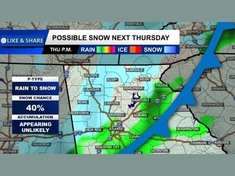
Rain May Mix With Snow Later in the Day
As the system progresses, temperatures could gradually cool later Sunday, allowing rain to briefly mix with or change to snow in some areas. Forecast guidance suggests this is most likely west of Interstate 95, where colder air may arrive sooner.
Even in those locations, forecasters stress that little to no accumulation is expected, with surface temperatures remaining marginal and snowfall rates too light to produce impacts.
Coastal Areas Could See Flurries With No Impact
For communities east of I-95 and along the coast, including eastern North Carolina and coastal South Carolina, the chance of snow is even lower. While a few flakes are not completely out of the question near the end of the event, meteorologists do not expect any accumulation.
Rain is expected to remain the dominant precipitation type in these areas from start to finish.
Snow Probability Map Shows Very Low Odds
Forecast model blends overwhelmingly support a less than 5% chance of one inch of snow across most of the Carolinas. The highest probabilities remain confined to the western Piedmont and foothills of North Carolina, but even there, confidence in measurable snow remains low.
The probability sharply drops moving east toward central and coastal sections of both states.
Bottom Line: Not a Major Winter Event
Forecasters emphasize that this system does not appear to be a significant winter weather event for North Carolina or South Carolina. While temperatures may trend colder behind the system, snowfall chances are expected to remain minimal.
Meteorologists will continue to monitor trends over the next couple of days in case colder air arrives sooner than expected, but for now, confidence remains high that impacts will be limited.
Another forecast update is expected Friday morning as new data becomes available.
What do you think — were you hoping for snow, or are you relieved this system looks minor? Share your thoughts and stay up to date with regional weather coverage at SaludaStandard-Sentinel.com.