North Carolina and South Carolina Face Two Rounds of Severe Storms Sunday Night and Monday With Tornado Risk and Damaging Winds
NORTH CAROLINA AND SOUTH CAROLINA — Residents across the Carolinas are being urged to stay alert as meteorologists warn of two potential waves of severe weather expected to impact the region Sunday night and again on Monday. Forecast models show an elevated risk for damaging straight-line winds and possible tornadoes as strong storms move through both states.
Forecasters say the first round could develop Sunday evening while a more organized and potentially stronger system moves across the region Monday, bringing widespread thunderstorms capable of producing dangerous conditions.
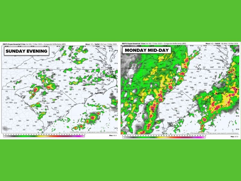
First Wave of Storms Possible Sunday Evening
Weather models indicate scattered thunderstorms may begin forming across parts of the western Carolinas and nearby areas Sunday evening. These storms could initially develop over portions of Tennessee and the Appalachian region before moving eastward into North Carolina and parts of South Carolina.
The storms are expected to be somewhat scattered at first, but some could intensify quickly. Meteorologists say the environment may support storms capable of producing damaging wind gusts and isolated tornadoes, especially in areas where stronger cells organize.
Cities including Charlotte, Hickory, and surrounding communities in western North Carolina could see storms developing earlier in the evening before activity gradually spreads eastward. Even storms that remain isolated could still produce intense rainfall, lightning, and brief severe wind gusts.
Stronger Line of Storms Possible Monday Midday
The second and potentially more widespread wave of severe weather is expected Monday as a strong line of thunderstorms organizes across the Southeast.
Forecast models show a long line of storms stretching from Alabama and Georgia into the Carolinas by midday Monday. As this line moves east, it could bring heavy rain, damaging wind gusts, and a continued tornado threat. The strongest storms may track through portions of western and central North Carolina before moving toward the Piedmont and eventually the coastal plain.
Communities including Charlotte, Greensboro, Winston-Salem, and Raleigh could see impacts if the line maintains strength while moving eastward. Storms embedded within the line may produce brief tornadoes or powerful straight-line wind gusts capable of downing trees and power lines.
Why Forecasters Are Watching This Setup Closely
Meteorologists note that the atmosphere will likely remain unstable across the Southeast during this period, allowing storms to regenerate as the system moves across the region. Warm and moist air flowing northward from the Gulf of Mexico will help fuel thunderstorm development, while a strong upper-level disturbance provides the lift needed for storms to intensify.
This combination can create the kind of environment where severe storms form in multiple waves instead of a single event. Because of this, forecasters are emphasizing the importance of remaining weather aware for an extended period, not just during one storm window.
Residents Urged to Prepare and Monitor Warnings
Emergency officials often recommend having multiple ways to receive severe weather alerts, especially when storms are expected overnight or during work hours.
Weather radios, smartphone alerts, and local broadcast updates are among the most reliable ways to receive warnings quickly if tornado warnings or severe thunderstorm warnings are issued. Residents should also secure outdoor items, review emergency plans, and remain prepared to move to safe shelter if warnings are issued.
With storms possible Sunday evening and again Monday, forecasters stress that the situation could evolve as new model data becomes available. Weather conditions can change rapidly during severe weather events, and updates may refine the timing or intensity of expected storms.
If severe weather develops in your community, share your experience or local conditions with the newsroom at SaludaStandard-Sentinel.com so others across the region can stay informed.