New Jersey, Pennsylvania and Delaware Face Final Squall Line With 50 MPH Winds and Sudden Snow Threat Late Tonight
NEW JERSEY — A powerful squall line is making its final push across New Jersey, Pennsylvania, and Delaware late this evening, bringing the risk of damaging wind gusts up to 50 mph along with a sudden burst of snow trailing behind the storms.
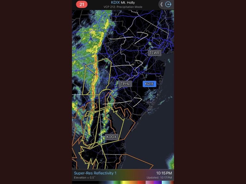
Weather radar from the region shows a well-defined line of intense storms advancing شرقward, marking the last phase of a system that has impacted much of the Mid-Atlantic throughout the day.
Final Squall Line Pushes Across Pennsylvania and New Jersey
The approaching squall line has formed into a narrow but intense band of heavy rain and embedded thunderstorms stretching from central Pennsylvania down through Delaware and into southern New Jersey.
Meteorologists indicate that this type of setup is capable of producing brief but powerful wind gusts, even without widespread severe thunderstorm warnings. The storms are moving quickly, meaning impacts in any one location may be short-lived but intense.
Areas near Philadelphia and surrounding suburbs are expected to experience the strongest part of the line as it moves through during the late evening hours.
Damaging Wind Gusts Up to 50 MPH Likely
Forecasters warn that wind gusts reaching up to 50 mph are likely as the squall line passes through. These winds can bring down tree limbs, cause isolated power outages, and create hazardous driving conditions, especially on bridges and open roadways.
The fast-moving nature of the line means that conditions can deteriorate rapidly, with a sudden increase in wind and heavy rain hitting with little warning. Residents are advised to secure loose outdoor items and remain indoors as the line moves through their area.
Brief Snow Burst Possible Behind the Storm Line
One of the more unusual aspects of this system is the potential for a quick transition from rain to snow immediately behind the squall line. As colder air rushes in, a brief period of snow or snow showers is expected across parts of eastern Pennsylvania, northern Delaware, and interior New Jersey.
While significant accumulation is not expected, the sudden change in conditions could lead to reduced visibility and slick spots on roads, particularly during the overnight hours. Temperatures are expected to drop quickly following the passage of the storms, reinforcing the wintry feel behind the system.
Rapid Clearing Expected After Storms Move Out
Once the squall line clears the coast, conditions are expected to improve quickly across the region. Skies will begin to clear, and winds will gradually ease overnight into early morning.
However, the colder air mass settling in behind the system will keep temperatures low, making for a chilly start to the next day across the Mid-Atlantic.
Meteorologists note that this system represents the final wave of active weather for now, with calmer conditions expected to follow in the short term.
Residents Urged to Stay Alert During Final Storm Passage
Even though this is the last round of storms from this system, officials emphasize that the impacts can still be significant. The combination of strong winds and a rapid temperature drop can catch people off guard.
Drivers, in particular, are urged to use caution as the line passes through and conditions change quickly from rain to gusty winds and possibly snow. If you experience strong winds or sudden snow in your area, share your updates with us and stay informed with continuing coverage on SaludaStandard-Sentinel.com.