New England Offshore Weather: Tropical Storm Drives 30-Foot Seas and Gale-Force Winds Through Friday
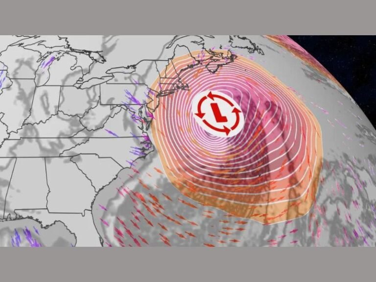
BOSTON, Mass. — Dangerous conditions are sweeping the Atlantic waters off New England and the Mid-Atlantic, as a strengthening tropical storm fuels seas climbing higher than 30 feet and winds reaching gale-to-storm force. The National Weather Service’s Ocean Prediction Center has extended tropical storm warnings across key offshore zones, urging all mariners to remain in port through the end of the week.
Warnings in Effect
The storm’s reach covers vast portions of the U.S. Eastern Seaboard, with warnings stretching from Long Island waters south to Cape Fear, North Carolina. Specific maritime regions under advisory include Georges Bank, Hudson Canyon, and offshore waters near Cape Hatteras.
- Winds: Forecast to peak between 40 and 55 knots (46–63 mph).
- Seas: Building to 20–37 feet in open waters, with localized crests surpassing 30 feet.
The highest waves are expected offshore North Carolina, where seas could exceed 36 feet by Thursday night. Meanwhile, mariners east of Cape Cod and south of Georges Bank may see 29-foot swells, while waters off Long Island are projected to reach 25 feet.
Impact on Coastal and Offshore Communities
The storm’s expansive footprint spans hundreds of miles, affecting major shipping and fishing lanes. Both U.S. Coast Guard units and local port authorities have issued urgent warnings for commercial fleets and recreational boaters alike:
“Remain docked until seas subside,” officials advised, citing the high likelihood of capsizing, equipment damage, and life-threatening conditions offshore.
Even though the storm’s center remains offshore, ripple effects are being felt onshore. The Outer Banks of North Carolina and parts of the New England coastline are experiencing dangerous rip currents, posing risks to swimmers and surfers despite otherwise calm beach conditions.
Timeline of the Storm
- Thursday Afternoon: Winds strengthen across offshore waters; seas rise rapidly.
- Thursday Night – Friday: Peak storm impact, with widespread 30+ foot seas and winds topping 50 knots.
- Saturday into Monday: Gradual improvement, though large swells will persist, keeping conditions risky for smaller vessels.
Forecasters say additional advisories are possible if the storm tracks further north before dissipating.
Historical Context
Tropical systems producing 30-foot seas in the North Atlantic are not uncommon during the late summer hurricane season, but such events remain rare and high-risk for maritime activity. The storm’s wide coverage across both New England and Mid-Atlantic waters marks it as one of the more dangerous offshore events of 2025.
Fishing operations in Georges Bank and Hudson Canyon are especially vulnerable. Delayed departures and disrupted shipping schedules are expected through the weekend, underscoring how offshore storms continue to ripple through the regional economy.
Safety Guidance
Authorities are reinforcing several key safety measures:
- Do not attempt offshore travel until conditions improve late Saturday.
- Check port updates frequently, as many harbors remain on storm footing.
- Avoid swimming and surfing in affected areas due to life-threatening rip currents.
- Recreational boaters should double-check moorings and keep vessels secured.
Looking Ahead
Conditions are forecast to gradually ease beginning Saturday, though marine forecasters warn that lingering swells may last into early next week. While the immediate tornado and inland flooding risks are minimal, the storm reinforces the unpredictable nature of Atlantic tropical activity as the peak of hurricane season nears.
Are you in New England or the Mid-Atlantic coast preparing for this tropical storm? Share your updates and experiences in the comments on SaludaStandard-Sentinel.com.