New England Braces for Midweek Snow Showers and Bitter Arctic Cold as Temperatures Drop Into Single Digits
CONNECTICUT — New England is heading into a stretch of snow showers and dangerously cold Arctic air as the region approaches the new year. Forecasters say passing snow bands between Tuesday and late Thursday could make travel difficult at times, while temperatures are expected to plunge into the single digits across the north and teens to 20s farther south.
Snow Showers From Tuesday Through Thursday
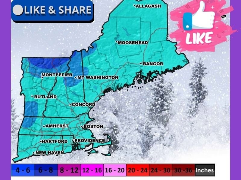
Meteorologists warn that between “now o’clock and late Thursday,” scattered snow showers will affect nearly every part of New England. The activity will vary from organized bands to quick, disorganized bursts — just enough to create slick and challenging travel conditions.
While these snow events are not expected to deliver heavy accumulation, even light snow could cause hazardous roadways, particularly for less experienced winter drivers. Some areas may see minor accumulation if a stronger snow band develops unexpectedly. The New England Weather Guy’s forecast map shows most regions receiving 0 to 4 inches, with slightly higher totals of 4 to 8 inches possible in pockets of Vermont and New Hampshire.
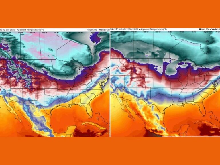
Arctic Air to Bring Single-Digit Highs and Subzero Lows
Forecasters say the more significant concern this week will be the deepening Arctic cold. Even daytime highs across much of New England are expected to remain well below freezing, with northern areas only reaching the single digits.
Overnight lows will fall into the single digits and below zero, creating a prolonged period where any lingering slush or ice will remain frozen. Meteorologists warn residents that accumulated frozen patches from recent weather “are not going away anytime soon.” These temperatures mark another surge of bitter cold for a region already used to harsh winter stretches but still vulnerable to icy conditions and dangerously low wind chills.
Travel and Safety Advisories
Drivers are urged to plan ahead, especially during early morning and evening hours when temperatures are at their lowest and travel risks increase. Forecasters note that even light snow combined with freezing temperatures may be enough to cause accidents or delays.
Residents are encouraged to:
- Clear walkways and driveways before temperatures drop further
- Prepare vehicles for cold-weather travel
- Dress in layers and limit outdoor activity during subzero wind chills
Officials stress that residents should pay extra attention to older adults, young children, and anyone without adequate heating during the cold stretch.
Regional Snapshot: Which States Will See the Coldest Conditions?
As winter deepens, several New England states are positioned to experience the harshest conditions this week. According to long-range observations, Connecticut, Rhode Island, Maine, Massachusetts, New Hampshire, and Vermont remain the most active states for winter complaints and weather-related concerns — a lighthearted recognition from the forecaster acknowledging residents’ frustration with relentless cold.
Still, meteorologists emphasize that the incoming Arctic stretch should be taken seriously due to prolonged subfreezing temperatures and the potential for icy roads. Residents across New England are encouraged to continue monitoring updated forecasts as conditions evolve. Share your local weather experiences and photos at SaludaStandard-Sentinel.com.