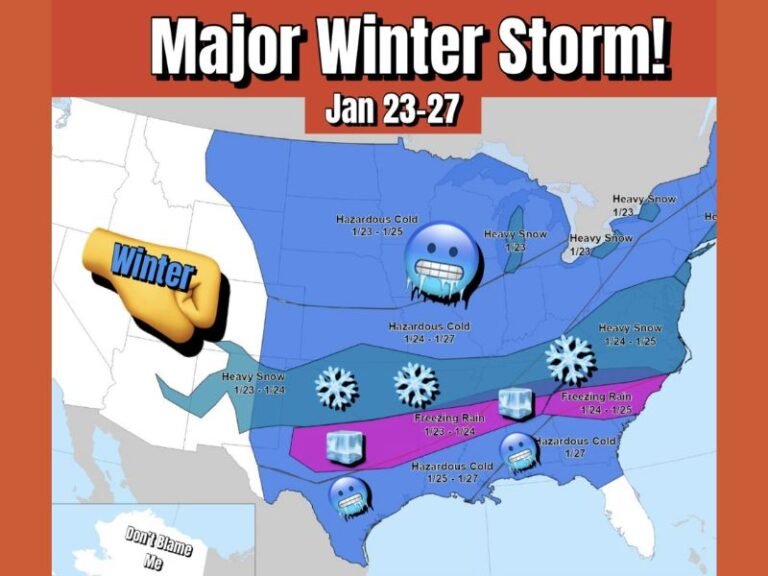
Missouri, Arkansas, and West Tennessee Brace for Icy Mix of Snow, Sleet, and Freezing Rain Through Tuesday
MISSOURI — Residents across Missouri, Arkansas, and West Tennessee are preparing for a dangerous mix of snow, sleet, and freezing rain that could make roads treacherous and lead to power outages through early Tuesday, according to the latest weather models.
Forecasters say the system, now pushing across the central United States, will deliver a triple threat of wintry precipitation — with gray zones marking snow, orange indicating sleet, and pink showing the highest threat for freezing rain.
Snow, Sleet, and Freezing Rain Collide
The NAM 3KM model shows the system intensifying Monday night into Tuesday morning.
- Northern Missouri is expected to see the heaviest snow, which could accumulate through Tuesday morning.
- Central and northern Arkansas will likely experience sleet, turning roads into slick, icy surfaces.
- West Tennessee, including Memphis and surrounding areas, could face periods of freezing rain, which may cause tree limbs and power lines to ice over.
Meteorologists warn that travel conditions could deteriorate quickly once temperatures fall below freezing, particularly on elevated surfaces like bridges and overpasses. Even a thin glaze of ice could make driving or walking extremely hazardous.
Forecast Timing and Impact
The cold front began sliding into the region Sunday night, with precipitation building from northwest to southeast. By Monday evening, forecasters expect the mix to expand and intensify, lasting into Tuesday morning.
The National Weather Service cautions that this storm system could bring localized power outages and travel disruptions, especially if freezing rain continues overnight.
“This isn’t a major snowstorm, but it’s the kind of event that can cause a mess on the roads and knock out power in localized areas,” one forecaster explained. “Even a small amount of ice can have a big impact.”
Missouri, Arkansas, and Tennessee Residents Warned to Stay Home
Across the affected region, officials are urging residents to avoid unnecessary travel and prepare for slippery conditions.
In Missouri, snow will be most concentrated from Kansas City to Columbia and into the eastern part of the state.
In Arkansas, temperatures will hover near freezing, increasing the chance of sleet and freezing rain from Little Rock to Jonesboro.
West Tennessee is expected to experience mixed precipitation, with the heaviest icing risks centered near Memphis and surrounding counties.
Residents are being advised to secure vehicles, check heating systems, and keep emergency kits ready in case of power loss.
Cold Pattern Continues
Meteorologists say the system is part of a broader cold-air outbreak sweeping across the Central and Southern Plains, marking the start of what could be an active early-December pattern. Additional waves of Arctic air are expected to reinforce the cold through next weekend.
Safety First
Officials emphasize that even moderate amounts of sleet or freezing rain can cause accidents and disrupt transportation. Drivers should slow down, avoid hills, and stay alert for rapidly changing road conditions.
Residents are also urged to monitor local forecasts and weather alerts as conditions evolve.
Stay safe and follow continuing coverage at SaludaStandard-Sentinel.com.