Minnesota Faces Near-Whiteout Travel Conditions From Blowing Snow and 50 MPH Winds as Western Wisconsin Records Higher Snowfall
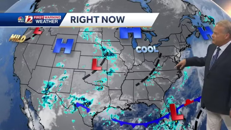
MINNESOTA — A dangerous combination of gusty winds and snow showers is expected to impact western and southern Minnesota from Thursday night into Friday, raising concerns for near-whiteout conditions, hazardous travel, and rapidly changing visibility, according to updated weather alerts.
Although the highest snow totals are forecast across western Wisconsin, forecasters warn that strong northwest wind gusts exceeding 40 mph, combined with falling and blowing snow, could create more severe travel impacts across parts of Minnesota, particularly in open and rural areas.
Winter Weather Advisory Issued for Impacted Areas
A Winter Weather Advisory has been issued for much of western and southern Minnesota, where wind gusts of 40 to 50 mph are expected in unsheltered locations. These strong winds will blow existing and falling snow, sharply reducing visibility even during periods of lighter snowfall.
Officials caution that near-whiteout conditions may develop rapidly within snow showers, leaving little time for drivers to react.
Snow Arrives in Multiple Rounds Through Friday
Snow is expected to arrive in several waves beginning Thursday evening and continuing through much of Friday. While snowfall amounts are generally forecast to remain between 1 and 4 inches by Saturday morning, the persistent wind is expected to dramatically worsen conditions.
Rather than accumulation alone, blowing and drifting snow will be the primary hazard, especially on north-south roadways and in exposed farmland areas.
Strong Winds Will Be the Biggest Threat
Forecast wind gust data shows sustained northwest winds with frequent gusts exceeding 40 mph, capable of lifting loose snow and creating ground blizzard-like conditions, even when snowfall rates are low.
These conditions may lead to:
- Sudden drops in visibility
- Snow-covered and icy roads
- Difficult travel for high-profile vehicles
- Rapidly changing road conditions
Western Wisconsin Sees Higher Snow Totals, Minnesota Faces Greater Travel Risk
While western Wisconsin is expected to receive the highest overall snowfall totals, meteorologists emphasize that western and southern Minnesota may experience the worst travel impacts due to the combination of strong winds and ongoing snow showers.
This setup increases the likelihood of temporary road closures, spin-outs, and slow travel, particularly during peak commute hours on Friday.
What Residents Should Prepare For
- Wind gusts up to 50 mph
- Blowing snow and reduced visibility
- Near-whiteout conditions developing quickly
- Hazardous travel Thursday night through Friday
- Difficult driving on rural and open highways
Drivers are urged to slow down, use headlights, and be prepared for sudden visibility loss. Those without essential travel are encouraged to delay trips until conditions improve.
Forecasters stress that conditions may deteriorate quickly with little warning, and even short-distance travel could become dangerous during peak snow showers. For continued winter weather updates and regional advisories, visit SaludaStandard-Sentinel.com.