Michigan, Wisconsin and Northern Indiana See Overnight Rain Band Push Southeast With Thunder Risk Early April 9
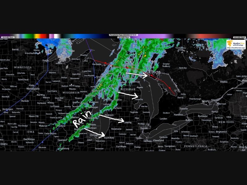
MICHIGAN — A steady band of rain is moving across the western Lower Peninsula early Thursday morning, with showers tracking southeast as of around 12:20 a.m. EDT on April 9.
Radar imagery shows a well-defined line of precipitation stretching from northern Wisconsin through central Michigan, gradually sweeping across key areas including Lansing and toward Detroit. The system is expected to continue its east-southeast progression through the overnight hours, bringing widespread rainfall and the possibility of isolated thunder.
Rain Band Tracking From Wisconsin Into Michigan Overnight
The current weather setup shows a long, narrow band of rain extending from parts of Wisconsin into Michigan’s Lower Peninsula. This system is pushing steadily southeast, impacting communities from the Lake Michigan shoreline inland toward central and eastern Michigan.
Cities including Grand Rapids, Lansing, and surrounding areas are directly in the path of this rain band. As the system advances, it is expected to continue spreading precipitation toward Detroit and into northern Indiana.
The consistent structure of the rain band suggests a prolonged period of steady rainfall rather than scattered showers, which could lead to brief periods of moderate rain intensity.
Thunder Cannot Be Ruled Out With Passing System
While the primary impact remains rainfall, there is also a chance of isolated thunder embedded within the system. Atmospheric conditions appear supportive of occasional rumbles, especially as the system interacts with slightly warmer air moving into parts of southern Michigan.
These thunderstorms are not expected to be severe, but lightning and brief heavier downpours could occur in localized pockets. Overnight travelers and early morning commuters should remain aware of changing conditions.
Southeast Movement Brings Rain Toward Indiana and Ohio
As the rain band continues its southeast trajectory, areas in northern Indiana and eventually northwest Ohio will begin to see increasing cloud cover and rainfall. The system’s forward motion indicates a steady progression rather than rapid movement, meaning rain could linger for several hours in affected areas.
This type of setup often results in a gradual transition, where rain begins light and becomes steadier before tapering off behind the main band.
Early Morning Impacts and What to Expect Next
By early morning, much of southern Michigan and nearby regions could still be dealing with lingering showers. Road conditions may become slick, especially in urban corridors where overnight rainfall accumulates.
The overall system does not appear to bring severe weather, but its widespread coverage ensures that many communities will experience wet conditions through the start of the day.
Residents are advised to plan for wet roads, reduced visibility at times, and the possibility of brief thunder as the system continues to pass through. If you’re seeing rain or hearing thunder in your area, share your conditions and join the conversation at SaludaStandard-Sentinel.com.